IMAGES TAKEN NEAR TO
Riverside Business Park, New Passage Hill, PLYMOUTH, PL1 4SN
Introduction
This page details the photographs taken nearby to Riverside Business Park, New Passage Hill, PL1 4SN by members of the Geograph project.
The Geograph project started in 2005 with the aim of publishing, organising and preserving representative images for every square kilometre of Great Britain, Ireland and the Isle of Man.

There are currently over 7.5m images from over14,400 individuals and you can help contribute to the project by visiting https://www.geograph.org.uk
Image Map
Images are licensed for reuse under creativecommons.org/licenses/by-sa/2.0
Notes
- Clicking on the map will re-center to the selected point.
- The higher the marker number, the further away the image location is from the centre of the postcode.
Image Listing (127 Images Found)
Images are licensed for reuse under creativecommons.org/licenses/by-sa/2.0
Image
Details
Distance
1
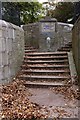
Steps, Devonport Park
These distinctive steps dating from 1857-8 lead up from New Passage Hill.
Image: © Derek Harper
Taken: 17 Oct 2015
0.03 miles
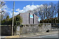
5
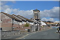
Plymouth: St Aubyn Road
The towers date from 1862 when a memorial stone was placed by the Earl of Mount Edgcumbe. Their function has been obscured by later buildings
Image: © Martin Bodman
Taken: 12 Feb 2008
0.05 miles
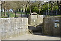
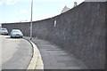
7

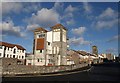
Dock Wall, New Passage Hill
Grade II listed. http://www.britishlistedbuildings.co.uk/en-476506-north-gate-and-attached-dockyard-walls-
Image: © N Chadwick
Taken: 16 Apr 2016
0.06 miles
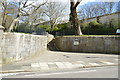
8
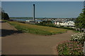
Devonport Park
A path junction south of Ferry Road, with a view over the Hamoaze to Torpoint and St John's Lake. The chimney is on dockyard property. The park is described at https://www.historicengland.org.uk/listing/the-list/list-entry/1001657 .
Image: © Derek Harper
Taken: 19 May 2018
0.06 miles
9
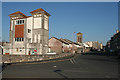
Towers in Devonport
This is almost identical to Image, apart from the addition of flats on Wright Close on the left. The towers, including the one further along the road, at the entrance to Washbourne Close, were part of the former Royal Albert Hospital and Eye Infirmary http://www.plymouthdata.info/Hospitals-Royal%20Albert%20DEV.htm , which closed in 1981 when Derriford opened. The view is across New Passage Hill at its junction with Morice Square and Marlborough Street.
Image: © Derek Harper
Taken: 30 Jan 2010
0.07 miles
10
Dock Wall, New Passage Hill
Grade II listed. http://www.britishlistedbuildings.co.uk/en-476506-north-gate-and-attached-dockyard-walls-
Image: © N Chadwick
Taken: 16 Apr 2016
0.07 miles