IMAGES TAKEN NEAR TO
H M Dockyard, PLYMOUTH, PL1 4SB
Introduction
This page details the photographs taken nearby to H M Dockyard, PL1 4SB by members of the Geograph project.
The Geograph project started in 2005 with the aim of publishing, organising and preserving representative images for every square kilometre of Great Britain, Ireland and the Isle of Man.

There are currently over 7.5m images from over14,400 individuals and you can help contribute to the project by visiting https://www.geograph.org.uk
Image Map
Images are licensed for reuse under creativecommons.org/licenses/by-sa/2.0
Notes
- Clicking on the map will re-center to the selected point.
- The higher the marker number, the further away the image location is from the centre of the postcode.
Image Listing (115 Images Found)
Images are licensed for reuse under creativecommons.org/licenses/by-sa/2.0
Image
Details
Distance
1
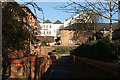
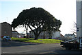
Plymouth: Morice Town
Housing behind the Royal Fleet Club, an hotel: it is the white building in the background
Image: © Martin Bodman
Taken: 12 Feb 2008
0.04 miles
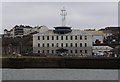
3
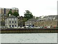
Historic naval stores buildings, Devonport dockyard
Left to right these are:
No.8 store, built 1722 with upper floors added in the 20th century. Listed Grade II.
No.6 Sail Loft (part hidden, with arched entrances) and No. 5 Store Colour Loft, both built in the 1840s, both Listed Grade II.
No.4 Store, one of the original Ordnance stores, for gun carriages and equipment, dated 1723, Listed Grade II*.
The large residential building at the back is the Officers' Terrace of 5 houses and stables, built 1720-24 and Listed Grade II*. The retaining wall and steps between the two levels date from the same period and are also Listed Grade II*.
Image: © Alan Murray-Rust
Taken: 30 Jun 2023
0.07 miles
5
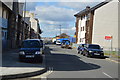
Plymouth: Morice Square
A green space in Morice Town - by the Royal Fleet Club, extreme right, and Marlborough Street
Image: © Martin Bodman
Taken: 12 Feb 2008
0.07 miles
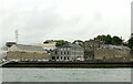
6
Historic naval stores buildings, Devonport dockyard
These are:
Left No. 5 Store Colour Loft, Centre No.3 store, both built in the 1840s, both Listed Grade II.
Right No.4 Store, one of the original Ordnance stores, for gun carriages and equipment, dated 1723, Listed Grade II*.
Image: © Alan Murray-Rust
Taken: 30 Jun 2023
0.07 miles
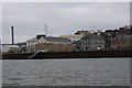
8
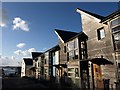
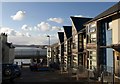
Cornwall Street, Devonport
As in: the street leading to the spot on the Tamar where you catch a boat for Cornwall. This forms the central corridor of a little area hemmed in by dockyard to the north and south and known as North Corner. When I worked near here in 2003 this was a wasteland http://www.webrarian.co.uk/devonport/index.html with just a couple of old pubs down by the water's edge. These smart new houses have appeared since.
Image: © Derek Harper
Taken: 30 Jan 2010
0.07 miles
10
Cornwall Street, Devonport
The lower half of Image (which shows the upper, eastern, half) with the roofs on the new houses on the northern side showing the same sail-like motif. On the left is The Swan pub, one of the few remaining buildings from pre-war days.
Image: © Derek Harper
Taken: 30 Jan 2010
0.08 miles