IMAGES TAKEN NEAR TO
Prospect Row, PLYMOUTH, PL1 4LE
Introduction
This page details the photographs taken nearby to Prospect Row, PL1 4LE by members of the Geograph project.
The Geograph project started in 2005 with the aim of publishing, organising and preserving representative images for every square kilometre of Great Britain, Ireland and the Isle of Man.

There are currently over 7.5m images from over14,400 individuals and you can help contribute to the project by visiting https://www.geograph.org.uk
Image Map
Images are licensed for reuse under creativecommons.org/licenses/by-sa/2.0
Notes
- Clicking on the map will re-center to the selected point.
- The higher the marker number, the further away the image location is from the centre of the postcode.
Image Listing (173 Images Found)
Images are licensed for reuse under creativecommons.org/licenses/by-sa/2.0
Image
Details
Distance
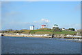
1
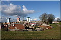
North from Mount Wise Park
In the foreground are buildings on Garrison Close. The underground structure on the right at the edge of the park may be part of the Royal Laboratory, built in 1805 to manufacture ammunition for the Navy and later used as barracks - or could it be connected with Maritime Headquarters? (though I think that was further east).
Beyond the grey housing around Ker Street rise three 47-metre 16-storey tower blocks dating from 1964 - Tavy House, Tamar House and Lynher House, each with about 90 flats.
Image: © Derek Harper
Taken: 30 Jan 2010
0.05 miles
2
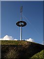
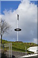
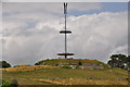
Mast at the Redoubt
This 40-metre high sculptural mast above Mount Wise Park was erected in 1998 on the site of the octagonal C18 Redoubt, which held gun batteries and a signalling station.
Image: © Derek Harper
Taken: 30 Jan 2010
0.08 miles
3
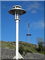
Mount Wise masts
Well the front one is a light on the promenade and the rear is a 40-metre high sculptural mast erected in 1998 on the site of the octagonal C18 Redoubt, which held gun batteries and a signalling station.
Image: © Steve Fareham
Taken: 29 Sep 2012
0.08 miles
4
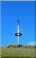
Sculptural mast on Mount Wise
This is a 40-metre high sculptural mast erected in 1998 on the site of the octagonal C18 Redoubt, which held gun batteries and a signalling station.
Image: © Steve Fareham
Taken: 29 Sep 2012
0.08 miles
5
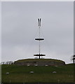
Telecommunication mast at Mount Wise, Plymouth
Image: © Ian S
Taken: 7 Mar 2015
0.08 miles
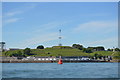
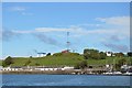
6
Plymouth : Mount Wise Park
The highest point of the park has variously been home to Mount Wise House, Mount Wise Fort, Mount Wise Signalling Station and since 1998, a circular viewing platform offering 360 degree views. Under the park, Second World War tunnels and a Cold War nuclear bunker have been carved out of the rock.
Image: © Lewis Clarke
Taken: 17 Jul 2015
0.08 miles