IMAGES TAKEN NEAR TO
Marlborough Street, PLYMOUTH, PL1 4AH
Introduction
This page details the photographs taken nearby to Marlborough Street, PL1 4AH by members of the Geograph project.
The Geograph project started in 2005 with the aim of publishing, organising and preserving representative images for every square kilometre of Great Britain, Ireland and the Isle of Man.

There are currently over 7.5m images from over14,400 individuals and you can help contribute to the project by visiting https://www.geograph.org.uk
Image Map
Images are licensed for reuse under creativecommons.org/licenses/by-sa/2.0
Notes
- Clicking on the map will re-center to the selected point.
- The higher the marker number, the further away the image location is from the centre of the postcode.
Image Listing (124 Images Found)
Images are licensed for reuse under creativecommons.org/licenses/by-sa/2.0
Image
Details
Distance
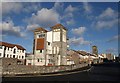
3
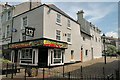
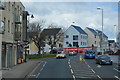
Casey's Pub on Marlborough Street, Devonport.
This area is undergoing a developmental upgrade as part of the dockyard is opened for housing and commercial use.
Image: © john spivey
Taken: 7 Aug 2005
0.06 miles
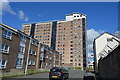
5
Albany Street, Devonport
A 13-storey block of flats dominates this view along the street next to the Granby Gate entrance to the dockyard.
Image: © Derek Harper
Taken: 30 Jan 2010
0.07 miles
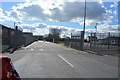
6
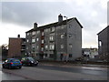
Block of flats on Park Avenue
Scheduled for demolition.
Image: © JThomas
Taken: 7 Nov 2014
0.07 miles
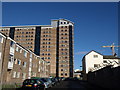
8
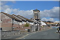
Towers in Devonport
This is almost identical to Image, apart from the addition of flats on Wright Close on the left. The towers, including the one further along the road, at the entrance to Washbourne Close, were part of the former Royal Albert Hospital and Eye Infirmary http://www.plymouthdata.info/Hospitals-Royal%20Albert%20DEV.htm , which closed in 1981 when Derriford opened. The view is across New Passage Hill at its junction with Morice Square and Marlborough Street.
Image: © Derek Harper
Taken: 30 Jan 2010
0.08 miles