IMAGES TAKEN NEAR TO
LISKEARD, PL14 6RZ
Introduction
This page details the photographs taken nearby to PL14 6RZ by members of the Geograph project.
The Geograph project started in 2005 with the aim of publishing, organising and preserving representative images for every square kilometre of Great Britain, Ireland and the Isle of Man.

There are currently over 7.5m images from over14,400 individuals and you can help contribute to the project by visiting https://www.geograph.org.uk
Image Map (Loading...)


Getting Data...Please wait
Leaflet Map data © OpenStreetMap
Images are licensed for reuse under creativecommons.org/licenses/by-sa/2.0
Notes
- Clicking on the map will re-center to the selected point.
- The higher the marker number, the further away the image location is from the centre of the postcode.
Image Listing (3 Images Found)
Images are licensed for reuse under creativecommons.org/licenses/by-sa/2.0
Image
Details
Distance
1
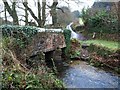
Trenant Bridge
The bridge carries the lane from Draynes to St Neot across a tributary of the Fowey. Beyond the lane climbs towards Treverbyn, with Pethiock Wood on the right.
Image: © Derek Harper
Taken: 28 Feb 2008
0.19 miles
2
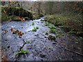
Stream at Trenant
The stream, wide and shallow at this point, has just passed under Image and is flowing away from the camera to meet the River Fowey in about 300 metres.
Image: © Derek Harper
Taken: 28 Feb 2008
0.20 miles
3
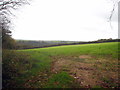
Field between West Draynes and Higher Trenant
Periock Wood is in the distance.
Image: © Rod Allday
Taken: 28 Oct 2012
0.23 miles