IMAGES TAKEN NEAR TO
Two Waters Foot, LISKEARD, PL14 6HS
Introduction
This page details the photographs taken nearby to PL14 6HS by members of the Geograph project.
The Geograph project started in 2005 with the aim of publishing, organising and preserving representative images for every square kilometre of Great Britain, Ireland and the Isle of Man.

There are currently over 7.5m images from over14,400 individuals and you can help contribute to the project by visiting https://www.geograph.org.uk
Image Map
Images are licensed for reuse under creativecommons.org/licenses/by-sa/2.0
Notes
- Clicking on the map will re-center to the selected point.
- The higher the marker number, the further away the image location is from the centre of the postcode.
Image Listing (3 Images Found)
Images are licensed for reuse under creativecommons.org/licenses/by-sa/2.0
Image
Details
Distance
1
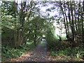
Road to Higher Derricombe
Starting to look autumnal!
Image: © Jonathan Billinger
Taken: 3 Oct 2007
0.02 miles
2
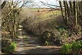
Drive to Higher Derricombe
The private drive from the road down Derricombe from the A390, at the upper edge of the woods that coat the Fowey valley and its side combes.
Image: © Derek Harper
Taken: 31 Mar 2016
0.05 miles
3
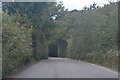
Braddock : North Lane
A lane heads through the countryside.
Image: © Lewis Clarke
Taken: 26 Sep 2022
0.10 miles