IMAGES TAKEN NEAR TO
Penvale, Shute Lane, LISKEARD, PL14 5QA
Introduction
This page details the photographs taken nearby to Penvale, Shute Lane, PL14 5QA by members of the Geograph project.
The Geograph project started in 2005 with the aim of publishing, organising and preserving representative images for every square kilometre of Great Britain, Ireland and the Isle of Man.

There are currently over 7.5m images from over14,400 individuals and you can help contribute to the project by visiting https://www.geograph.org.uk
Image Map (Loading...)


Getting Data...Please wait
Leaflet Map data © OpenStreetMap
Images are licensed for reuse under creativecommons.org/licenses/by-sa/2.0
Notes
- Clicking on the map will re-center to the selected point.
- The higher the marker number, the further away the image location is from the centre of the postcode.
Image Listing (31 Images Found)
Images are licensed for reuse under creativecommons.org/licenses/by-sa/2.0
Image
Details
Distance
1
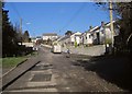
Shute Hill, Pensilva
The lane has come from Woolston and here becomes built-up on both sides as it climbs towards the junction with Fore Street.
Image: © Derek Harper
Taken: 13 Dec 2014
0.01 miles
2
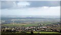
Pensilva from Caradon Hill
Taken from a little south of the television station on the summit. That'll be the wind turbine shown in Image
Image: © Derek Harper
Taken: 13 Dec 2014
0.09 miles
3
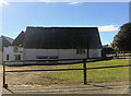
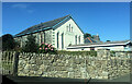
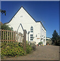
Pensilva Methodist Church
Image: © Derek Harper
Taken: 13 Dec 2014
0.10 miles
4
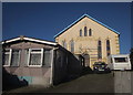
Pensilva Methodist Church
Dated 1861, this "United Methodist Church" is on Fore Street, and is described at http://www.historic-cornwall.org.uk/cisi/pensilva/CISI_Pensilva_report.pdf as a Bible Christian Chapel. It is now undergoing conversion, I think into flats. At the time of its construction, Pensilva was called Bodminland.
Image: © Derek Harper
Taken: 13 Dec 2014
0.10 miles
6
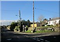
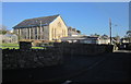
Fore Street, Pensilva
With the junction at the foot of Wesley Road.
Image: © Derek Harper
Taken: 13 Dec 2014
0.12 miles
7
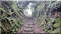
Steep Footpath between Shute Lane and Quarry Road
The road names have a mining theme because the houses once had miners living here.
Image: © James Emmans
Taken: 27 May 2016
0.14 miles
9
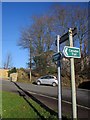
Caradon Trail at Pensilva
The Trail http://www.visitliskeard.co.uk/wp-content/uploads/Caradon-Trail-Leaflet-2.pdf only opened in February 2014 and, at the time of submission, has yet to feature on the 1:25000 OS map. These signs are at the junction of Princess Road and School Road (background).
Image: © Derek Harper
Taken: 13 Dec 2014
0.15 miles