IMAGES TAKEN NEAR TO
Rosecraddoc, LISKEARD, PL14 5FB
Introduction
This page details the photographs taken nearby to Rosecraddoc, PL14 5FB by members of the Geograph project.
The Geograph project started in 2005 with the aim of publishing, organising and preserving representative images for every square kilometre of Great Britain, Ireland and the Isle of Man.

There are currently over 7.5m images from over14,400 individuals and you can help contribute to the project by visiting https://www.geograph.org.uk
Image Map
Images are licensed for reuse under creativecommons.org/licenses/by-sa/2.0
Notes
- Clicking on the map will re-center to the selected point.
- The higher the marker number, the further away the image location is from the centre of the postcode.
Image Listing (11 Images Found)
Images are licensed for reuse under creativecommons.org/licenses/by-sa/2.0
Image
Details
Distance
1
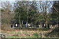
Holiday cottages behind the trees
Much of Rosecraddoc Estate has been turned into a holiday village.
Image: © Tony Atkin
Taken: 10 Mar 2007
0.10 miles
3
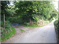
Quarry entrance at Rosecraddoc
The quarry is now disused.
Image: © Rod Allday
Taken: 18 Sep 2010
0.12 miles
4
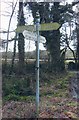
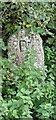
Old Direction Sign - Signpost by the B3254, Lower Treneath
Ball & cone finial - by the B3254, South of stream bridge in parish of Liskeard (Caradon District), opposite gate at Rosecraddoc Manor, Lower Treneath, at offset crossroads.
Surveyed
Milestone Society National ID: CW_SX2667.
Image: © Milestone Society
Taken: Unknown
0.17 miles
5
Old Boundary Marker beside the B3254
Parish Boundary Marker on the southeast side of the B3254 opposite to the entrance to the Rosecraddoc Holiday Village. On the boundary of Liskeard and St Cleer parishes.
Milestone Society National ID: CW_LISSCL01pb
Image: © L Nicholls
Taken: 1 Oct 2023
0.17 miles
7
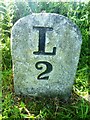
Old Milestone by the B3254, north east of Lower Treneath
Carved stone post by the B3254, in parish of LISKEARD (CARADON District), Lower Treneath, St Cleer Road, Roscraddoc Manor lodge, 15m from 'B' stone, on East side of road. Launceston pillar, erected by the Liskeard turnpike trust in the 18th century.
Inscription reads:-
L
2
Grade II listed.
List Entry Number: 1203193 https://historicengland.org.uk/listing/the-list/list-entry/1203193
Milestone Society National ID: CW_LKCE02.
Image: © Rosy Hanns
Taken: 19 May 2019
0.18 miles
8
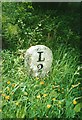
Old Milestone by the B3254, north east of Lower Treneath
Carved stone post by the B3254, in parish of LISKEARD (CARADON District), Lower Treneath, St Cleer Road, Roscraddoc Manor lodge; 15m from B stone, on East side of road. Launceston pillar, erected by the Liskeard turnpike trust in the 18th century.
Inscription reads:-
L
2
Grade II Listed. List Entry Number: 1203193
https://historicengland.org.uk/listing/the-list/list-entry/1203193
Milestone Society National ID: CW_LKCE02.
Image: © Ian Thompson
Taken: 1 May 2001
0.18 miles
9
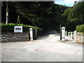
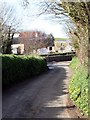
The entrance to Rosecraddoc Manor
The manor was built in the 1820s on the site of a much older house mentioned in the Domesday Book. It is Grade II listed, along with two bridges in the grounds, and has now been converted into holiday apartments and villas http://rosecraddocmanor.co.uk.
Image: © Rod Allday
Taken: 18 Sep 2010
0.22 miles
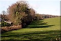
10
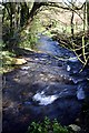
Stream below Rosecraddoc
The weather is dry but the previous weeks have seen a huge amount of rain and the stream still runs deep and fast.
Image: © Tony Atkin
Taken: 10 Mar 2007
0.22 miles