IMAGES TAKEN NEAR TO
St. Cleer, LISKEARD, PL14 5EA
Introduction
This page details the photographs taken nearby to PL14 5EA by members of the Geograph project.
The Geograph project started in 2005 with the aim of publishing, organising and preserving representative images for every square kilometre of Great Britain, Ireland and the Isle of Man.

There are currently over 7.5m images from over14,400 individuals and you can help contribute to the project by visiting https://www.geograph.org.uk
Image Map (Loading...)


Getting Data...Please wait
Leaflet Map data © OpenStreetMap
Images are licensed for reuse under creativecommons.org/licenses/by-sa/2.0
Notes
- Clicking on the map will re-center to the selected point.
- The higher the marker number, the further away the image location is from the centre of the postcode.
Image Listing (21 Images Found)
Images are licensed for reuse under creativecommons.org/licenses/by-sa/2.0
Image
Details
Distance
1

Liskeard & Caradon railway St Cleer goods shed
The former St Cleer goods shed operated by the now defunct Liskeard & Caradon Railway was in a poor state in submission Image The building has now been incorporated into a domestic dwelling, now under construction and at least saved from demolition.
Image: © St Clarus
Taken: 12 Dec 2015
0.00 miles
2
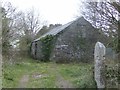
Liskeard and Caradon Railway St. Cleer goods shed
During the lifetime of the Liskeard and Caradon Railway, which was built to move mined ore's down to Moorswater, a number of goods sheds were built to serve the local villages with supplies. There were buildings at Sharptor,Tokenbury (For Pensilva),Polwrath and St. Cleer. Only the St. Cleer shed remains, the others having all been demolished. This historic building is now the subject of a planning application for houses, and is threatened with a similar fate. It deserves to be preserved as it is a unique example of a building of great cultural importance.
Image: © Eric Foster
Taken: 6 Apr 2012
0.00 miles
3
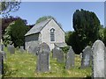
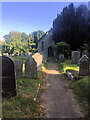
The St. Cleer Dissenters Chapel
It was thanks to the creation of one of the earliest manifestations of Trade Unionism, namely the Caradon Miners' and Mechanics' Friendly Society in 1842 that led to the building of the St. Cleer Dissenters chapel in 1864 by these same men. Built for the benefit of persons who were denied burial by the established church after a lifetime of nonconformity, the chapel continues to this day to accommodate all faiths and beliefs, carrying on the original aims of those early pioneers. At the time of its construction, the population of the parish was 3931, a figure that has to this date not been exceeded, in fact in 1961 the figure was 1524. The high population in 1864 was of course due to the large influx of people seeking work in the Caradon mining area, although at that time the boom was already over and workers began to move to other areas, including overseas. At least seven non-conformist chapels existed in the area, most now however have been converted to private dwellings. The chapel and cemetery are administered by four trustees, and much work has been done in the grounds by local volunteers. The chapel itself has also had a sympathetic renovation. The cemetery is still in use, a number of plots being reserved as it is expected that none will be available in around 20 years. An excellent web site exists at http://thedissentersgeneralchapel.co.uk. Here can be found historical records, burial details and minutes of trustee meetings, along with other photographs and a record of flora and fauna identified on the site.
Image: © cornisharchive
Taken: 26 May 2012
0.03 miles
4
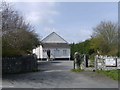
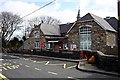
St. Cleer 'Memorial Hall'
A valuable asset to the village of St. Cleer, the Memorial Hall was built in 1954 as a tribute to the injured and fallen of the Second World War. The land on which the hall stands was given to the Trustees by the Trethevy Home Guard. Two hours before the railway nationalization came into effect in 1947 the then Great Western Railway gave permission for the Trustees to erect the hall, which stands on the old track way of the Liskeard and Caradon Railway, which they then owned. The track way continued on, across what is now a roadway to pass the St. Cleer goods shed. Image
Image: © Eric Foster
Taken: 6 Apr 2012
0.04 miles
5
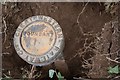
Old Boundary Marker
Railway Boundary Marker on the edge of a play area adjacent to the Memorial Hall on Well Lane. St Cleer parish. In raised lettering GREAT WESTERN RAILWAY Coy (around the outer edge) / BOUNDARY (in the centre).
Milestone Society National ID: CW_CLEER01em
Image: © B Oldham
Taken: 8 Jul 2020
0.07 miles
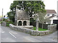
8
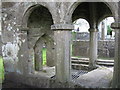
Close up of The Holy Well at St. Cleer, Cornwall
See also Image
Image: © Derek Voller
Taken: 25 Sep 2010
0.10 miles
9
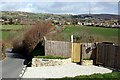
Valley north of St Cleer
To the north of St Cleer village there are several smaller settlements leading up to Caradon Hill (the one with the tall mast on top). These developed in the 19th century to house workers associated with the mines on the southern flank of Caradon Hill.
Image: © Tony Atkin
Taken: 10 Mar 2007
0.10 miles
10
The Holy Well of St. Cleer, Cornwall
The well, in ancient times, was used as a "bowsening" pool. Residents of the village who were thought to be mad were immersed in the water several times. This was believed to cure their insanity. See also Image
Image: © Derek Voller
Taken: 25 Sep 2010
0.11 miles