IMAGES TAKEN NEAR TO
Manor Park, LISKEARD, PL14 4PT
Introduction
This page details the photographs taken nearby to Manor Park, PL14 4PT by members of the Geograph project.
The Geograph project started in 2005 with the aim of publishing, organising and preserving representative images for every square kilometre of Great Britain, Ireland and the Isle of Man.

There are currently over 7.5m images from over14,400 individuals and you can help contribute to the project by visiting https://www.geograph.org.uk
Image Map
Images are licensed for reuse under creativecommons.org/licenses/by-sa/2.0
Notes
- Clicking on the map will re-center to the selected point.
- The higher the marker number, the further away the image location is from the centre of the postcode.
Image Listing (8 Images Found)
Images are licensed for reuse under creativecommons.org/licenses/by-sa/2.0
Image
Details
Distance
1
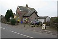
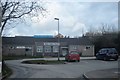
Post Office and Shop
This village still has its Post Office and shop . Many larger villages have lost them .
Image: © roger geach
Taken: 29 Nov 2008
0.04 miles
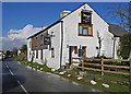
2
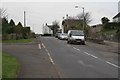
Duloe Village
Looking towards Dobwalls this is the Village at Duloe. The road to the left is a newer estate built in the 70s.
Image: © roger geach
Taken: 29 Nov 2008
0.07 miles
3
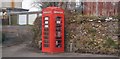
Duloe Book Store
An interesting use of an old phone box.
Image: © N Chadwick
Taken: 31 Mar 2018
0.09 miles
5
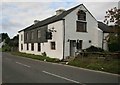
Plough House Inn Duloe
This inn is shut at the moment and is to let. Like many village pubs this has closed and awaits its fate.
Image: © roger geach
Taken: 25 Sep 2010
0.17 miles
7
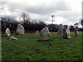
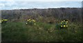
Duloe Stone Circle
Nine (Ten?) stones, all of solid quartz!
Image: © Alan Simkins
Taken: 7 Mar 2004
0.18 miles