IMAGES TAKEN NEAR TO
Moorswater, LISKEARD, PL14 4LB
Introduction
This page details the photographs taken nearby to PL14 4LB by members of the Geograph project.
The Geograph project started in 2005 with the aim of publishing, organising and preserving representative images for every square kilometre of Great Britain, Ireland and the Isle of Man.

There are currently over 7.5m images from over14,400 individuals and you can help contribute to the project by visiting https://www.geograph.org.uk
Image Map (Loading...)


Getting Data...Please wait
Leaflet Map data © OpenStreetMap
Images are licensed for reuse under creativecommons.org/licenses/by-sa/2.0
Notes
- Clicking on the map will re-center to the selected point.
- The higher the marker number, the further away the image location is from the centre of the postcode.
Image Listing (21 Images Found)
Images are licensed for reuse under creativecommons.org/licenses/by-sa/2.0
Image
Details
Distance
1

Trees by Looe Mills Farm
One by one these trees are being felled, but at least some remain, for the moment. This view is from the road along the Moorswater industrial estate.
Image: © Derek Harper
Taken: 20 Jan 2016
0.09 miles
2
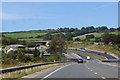
Over the hill
One of the more scenic sections of the A38.
Image: © Robert Ashby
Taken: 8 Aug 2015
0.09 miles
3

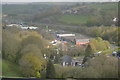
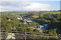
Industrial Units in the Valley
Looking north from a footbridge over the railway line.
Image: © Tony Atkin
Taken: 28 Dec 2005
0.13 miles
5
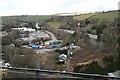
Industry at Moorswater
In the Looe Valley on the western side of Liskeard. This photo was taken from a train crossing the Moorswater Viaduct.
Image: © Tony Atkin
Taken: 5 Mar 2006
0.15 miles
6
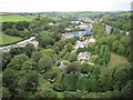
View from a Plymouth-Penzance train - Moorswater
Image: © Nigel Thompson
Taken: 15 Sep 2016
0.15 miles
8
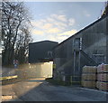
Bulk loading head and cement packing operation at Liskeard
Road tanker loading facility for Tarmac's bulk cement products, and a few pallets of bagged cement for distribution to local builders' merchants and the like.
Image: © Jack Gilligan
Taken: 4 Dec 2019
0.15 miles
9
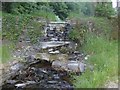
Old Stream Crossing
Close to the unadopted road, and adjacent to the footpath leading up towards Looe Mills Farm, is this small dam, creating the small pond behind it. An old crude footbridge can be seen in the foreground, although it is safer to get one's feet wet and walk across the water passing over the track!
Image: © Eric Foster
Taken: 16 Jun 2010
0.16 miles
10
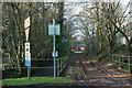
Siding, Moorswater
From a level crossing on the Moorswater road. On the left is the East Looe River.
Image: © Derek Harper
Taken: 20 Jan 2016
0.20 miles