IMAGES TAKEN NEAR TO
Donierts Close, LISKEARD, PL14 4HS
Introduction
This page details the photographs taken nearby to Donierts Close, PL14 4HS by members of the Geograph project.
The Geograph project started in 2005 with the aim of publishing, organising and preserving representative images for every square kilometre of Great Britain, Ireland and the Isle of Man.

There are currently over 7.5m images from over14,400 individuals and you can help contribute to the project by visiting https://www.geograph.org.uk
Image Map (Loading...)


Getting Data...Please wait
Leaflet Map data © OpenStreetMap
Images are licensed for reuse under creativecommons.org/licenses/by-sa/2.0
Notes
- Clicking on the map will re-center to the selected point.
- The higher the marker number, the further away the image location is from the centre of the postcode.
Image Listing (19 Images Found)
Images are licensed for reuse under creativecommons.org/licenses/by-sa/2.0
Image
Details
Distance
1
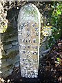
Old Milepost by the A390 in Liskeard
Cast iron post by the A390, in parish of LISKEARD (CARADON District), Dean Street, by Nos. 3 & 4, against wall, on North side of road. Erected by the Liskeard turnpike trust in the 19th century.
Inscription reads:-
: LISKEARD / ½ / MILE / TO THE / CROSS / IN / CHURCH / STREET / TORPOINT / 17 / MILES : : LOSTWITHOL / 11 / MILES :
Grade II Listed. List Entry Number: 1281826
https://historicengland.org.uk/listing/the-list/list-entry/1281826
Milestone Society National ID: CW_LSLK11.
Image: © Ian Thompson
Taken: 1 Apr 2003
0.08 miles
2
Old Milepost by the A390 in Liskeard
Cast iron post by the A390, in parish of LISKEARD (CARADON District), Dean Street, by Nos. 3 & 4, against wall, on North side of road. Erected by the Liskeard turnpike trust in the 19th century.
Inscription reads:-
: LISKEARD / ½ / MILE / TO THE / CROSS / IN / CHURCH / STREET / TORPOINT / 17 / MILES : : LOSTWITHOL / 11 / MILES :
Grade II listed.
List Entry Number: 1281826 https://historicengland.org.uk/listing/the-list/list-entry/1281826
Milestone Society National ID: CW_LSLK11.
Image: © Rosy Hanns
Taken: 14 Sep 2019
0.08 miles
3
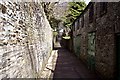
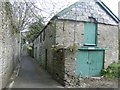
Westbourne Lane
Westbourne Lane is a narrow alleyway running between Westbourne Gardens on the left and what used to be the cattle market but is now a car park further along on the right.
Image: © Tony Atkin
Taken: 10 Mar 2007
0.13 miles
4
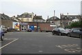
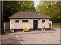
Back entrance to the Co-op
The view from the car park looking south we can see the Co-op. This supermarket has been here a few years now.
Image: © roger geach
Taken: 29 Nov 2008
0.17 miles
5
Old Mews of Westbourne House Liskeard
On the medieval track, now known as Westbourne Lane stands this derelict mews building, originally part of the Westbourne house complex that has been taken over as offices for Cornwall Council Social Services. Part of the grounds of the house are also now a Council owned car park known as Westbourne car park or the Co-op car park. This is a little used lane, an interesting walk but with a hint of sadness about it.
Image: © Eric Foster
Taken: 22 Mar 2012
0.18 miles
6
The White Horse from the rear exit
Taken from the car park this is the rear exit /egress to the White Horse pub and leads from the car park towards the Parade.
Image: © roger geach
Taken: 29 Nov 2008
0.19 miles
8
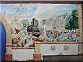
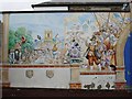
Mural in Liskeard
Part of a mural in Pigmeadow Lane depicting the history of Liskeard and South East Cornwall from earliest times. This panel shows the industrial revolution, the coming of the railway, and the consequent social and political impact. It is signed David Whittley and dated 1998.
The central panel (not photographed due to a parked car) depicts the Romano British warrior, Caradoc (aka Caractacus), historical evidence of any link between him and Liskeard or nearby Caradon Hill on Bodmin Moor is questionable.
More about the artist here (pdf) www.commissionaportrait.com/pdfs/116.pdf
See also http://www.geograph.org.uk/photo/195973
Image: © Penny Mayes
Taken: 27 Jun 2006
0.20 miles
9
Mural in Liskeard
Part of a mural in Pigmeadow Lane depicting the history of Liskeard and South East Cornwall from earliest times. It is signed David Whittley and dated 1998.
The central panel (not photographed due to a parked car) depicts the Romano British warrior, Caradoc (aka Caractacus), historical evidence of any link between him and Liskeard or nearby Caradon Hill on Bodmin Moor is questionable.
More about the artist here (pdf) www.commissionaportrait.com/pdfs/116.pdf
See also http://www.geograph.org.uk/photo/195963
Image: © Penny Mayes
Taken: 27 Jun 2006
0.20 miles
10
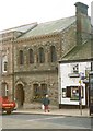
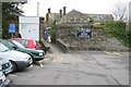
Building, Barras Street, Liskeard
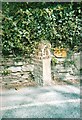
This building is between a bank and the White Horse Inn, and was an optician's when this photograph was taken in 2001. A 'Star of David' is carved over the door, and I have been informed that it was probably built for the Freemasons, who use that emblem. It is a Henry Rice building, he was the local architect who designed a large number of buildings in Liskeard in the Victorian era and many of his documents survive in local collections.
Image: © Humphrey Bolton
Taken: 9 Mar 2001
0.21 miles