IMAGES TAKEN NEAR TO
Mispickle Road, PL14 3XG
Introduction
This page details the photographs taken nearby to Mispickle Road, PL14 3XG by members of the Geograph project.
The Geograph project started in 2005 with the aim of publishing, organising and preserving representative images for every square kilometre of Great Britain, Ireland and the Isle of Man.

There are currently over 7.5m images from over14,400 individuals and you can help contribute to the project by visiting https://www.geograph.org.uk
Image Map (Loading...)


Getting Data...Please wait
Leaflet Map data © OpenStreetMap
Images are licensed for reuse under creativecommons.org/licenses/by-sa/2.0
Notes
- Clicking on the map will re-center to the selected point.
- The higher the marker number, the further away the image location is from the centre of the postcode.
Image Listing (6 Images Found)
Images are licensed for reuse under creativecommons.org/licenses/by-sa/2.0
Image
Details
Distance
1
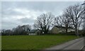
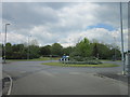
Sports ground by B3254 north of Liskeard
Image: © David Smith
Taken: 17 Mar 2022
0.14 miles
2
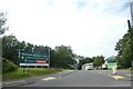
Carlton Way, Liskeard
Access road from the bypass to a growing (in 2021) housing estate
Image: © David Smith
Taken: 6 Jul 2021
0.18 miles
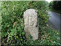
3
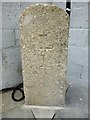
Old Milestone, formerly by the B3254, north of Trevecca Cottages
Carved stone post formerly by the B3254, North of Trevecca Cottages, in parish of LISKEARD (CARADON District). Removed to unidentified location in Addington, Liskeard. Launceston pillar, erected by the Liskeard turnpike trust in the 18th century.
Inscription reads:-
L
1
Grade II listed.
List Entry Number: 1203192 https://historicengland.org.uk/listing/the-list/list-entry/1203192
Milestone Society National ID: CW_LKCE01.
Image: © Rosy Hanns
Taken: 20 May 2019
0.18 miles
4
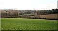
Farmland north of Liskeard
Looking east from the B3254 at Trevecca Cottages, further to the right than Image, with houses at Tremblaze visible.
Image: © Derek Harper
Taken: 24 Jan 2015
0.20 miles
5
The A390, Charter Way at Callington Road, Liskeard
Image: © Ian S
Taken: 25 May 2013
0.21 miles
6
Old Boundary Marker
Parish Boundary Marker on the southwest side of the junction of Culverland Road and Culverland Park, between the pavement and the road. On the former boundary of Liskeard Borough and Liskeard Parish. Inscribed B and P on opposite faces.
Milestone Society National ID: CW_LISK01pb
Image: © B Oldham
Taken: 27 Jun 2020
0.24 miles