IMAGES TAKEN NEAR TO
East Road, LISKEARD, PL14 3RR
Introduction
This page details the photographs taken nearby to East Road, PL14 3RR by members of the Geograph project.
The Geograph project started in 2005 with the aim of publishing, organising and preserving representative images for every square kilometre of Great Britain, Ireland and the Isle of Man.

There are currently over 7.5m images from over14,400 individuals and you can help contribute to the project by visiting https://www.geograph.org.uk
Image Map (Loading...)


Getting Data...Please wait
Leaflet Map data © OpenStreetMap
Images are licensed for reuse under creativecommons.org/licenses/by-sa/2.0
Notes
- Clicking on the map will re-center to the selected point.
- The higher the marker number, the further away the image location is from the centre of the postcode.
Image Listing (31 Images Found)
Images are licensed for reuse under creativecommons.org/licenses/by-sa/2.0
Image
Details
Distance
3
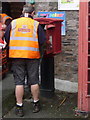
Menheniot: postbox № PL14 94
The postman opens this postbox, which is of the modern 'Type M' design and stands outside Image
Image: © Chris Downer
Taken: 18 Oct 2013
0.04 miles
4
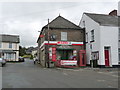
Menheniot: the shop/post office
A largeish Spar shop for a village of this size, with the post office contained within.
Image: © Chris Downer
Taken: 18 Oct 2013
0.04 miles
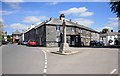
5
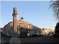
Menheniot
The scene also appears in Image; in this view the winter sun has only recently risen. Behind the war memorial are Poads Trust Almshouses, described at http://list.english-heritage.org.uk/resultsingle.aspx?uid=1140030&searchtype=mapsearch .
Image: © Derek Harper
Taken: 13 Dec 2014
0.04 miles
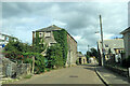
6
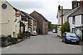
Menheniot
Menheniot is in many respects a typical 'parish village' with a church at its centre. It suffered great changes in the mid 19th century when for a short time lead was mined in the vicinity. A number of new houses have been built in the latter half of the 20th century which has kept the village population high enough to support a pub and a shop.
Image: © Tony Atkin
Taken: 13 May 2006
0.05 miles
7

Almshouses in Menheniot Village
Almshouses might be considered an early form of social housing. They were generally run by charities and often made stipulatations for tenancy, for example that they should be needy, regular church goers and clean. The designation 'Almshouse' now refers only to their former status.
Image: © Tony Atkin
Taken: 13 May 2006
0.05 miles
8
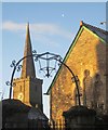
Overthrow, Menheniot
At the gates near the northeast of the churchyard. On the right is the Victorian Sunday School http://list.english-heritage.org.uk/resultsingle.aspx?uid=1329434&searchtype=mapsearch . In the background is the spire of Image In the sky are the moon and what appears to be a pigeon.
Image: © Derek Harper
Taken: 13 Dec 2014
0.05 miles
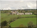
9
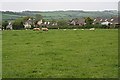
Sheep Grazing and Houses
This is on the eastern outskirts of the village of Menheniot
Image: © Tony Atkin
Taken: 13 May 2006
0.06 miles