IMAGES TAKEN NEAR TO
Merrymeet, LISKEARD, PL14 3LS
Introduction
This page details the photographs taken nearby to PL14 3LS by members of the Geograph project.
The Geograph project started in 2005 with the aim of publishing, organising and preserving representative images for every square kilometre of Great Britain, Ireland and the Isle of Man.

There are currently over 7.5m images from over14,400 individuals and you can help contribute to the project by visiting https://www.geograph.org.uk
Image Map (Loading...)


Getting Data...Please wait
Leaflet Map data © OpenStreetMap
Images are licensed for reuse under creativecommons.org/licenses/by-sa/2.0
Notes
- Clicking on the map will re-center to the selected point.
- The higher the marker number, the further away the image location is from the centre of the postcode.
Image Listing (19 Images Found)
Images are licensed for reuse under creativecommons.org/licenses/by-sa/2.0
Image
Details
Distance
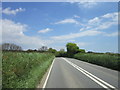
1
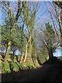
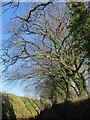
Lane near Lower Venton
Trees grow from the banks a little uphill from Image
Image: © Derek Harper
Taken: 13 Dec 2014
0.04 miles
2
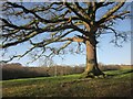
Oak near Lower Venton
By the lane shown in Image] as it climbs a little.
Image: © Derek Harper
Taken: 13 Dec 2014
0.05 miles
3
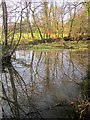
Pool near Lower Venton
This has formed beside the lane shown in Image] where two streams join on their way to meet the River Tiddy, and is close to the spot where Image was taken.
Image: © Derek Harper
Taken: 13 Dec 2014
0.06 miles
4
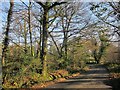
Lane to Butterdon
Running through damp woodland by a tributary of the Tiddy. Image was taken from the bend ahead.
Image: © Derek Harper
Taken: 13 Dec 2014
0.07 miles
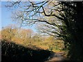
5
Lane near Lower Venton
Up the hill from Image], the lane approaches the A390 by running almost level for a while.
Image: © Derek Harper
Taken: 13 Dec 2014
0.08 miles
6
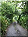
Lane to Lower Venton
Taken from near its junction with the A390 (see Image]) this little lane leads to Lower Venton.
Image: © Rob Farrow
Taken: 14 Aug 2007
0.10 miles
7
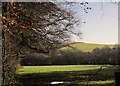
Field by the Tiddy
The River Tiddy flows past the little wood at the far end of this meadow. View from the lane past Lower Venton.
Image: © Derek Harper
Taken: 13 Dec 2014
0.14 miles
8
Lane near Treweatha
The lane below the farm approaches the junction with the lane to Tregarrick.
Image: © Derek Harper
Taken: 13 Dec 2014
0.14 miles
10
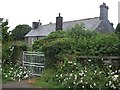
Treweatha
Snuggled behind a wall is the farmhouse at Treweatha. I think the large daisy-like flowers at the front are marguerites.
Image: © Rob Farrow
Taken: 14 Aug 2007
0.16 miles