IMAGES TAKEN NEAR TO
Tom Putt Mews, LISKEARD, PL14 3FY
Introduction
This page details the photographs taken nearby to Tom Putt Mews, PL14 3FY by members of the Geograph project.
The Geograph project started in 2005 with the aim of publishing, organising and preserving representative images for every square kilometre of Great Britain, Ireland and the Isle of Man.

There are currently over 7.5m images from over14,400 individuals and you can help contribute to the project by visiting https://www.geograph.org.uk
Image Map
Images are licensed for reuse under creativecommons.org/licenses/by-sa/2.0
Notes
- Clicking on the map will re-center to the selected point.
- The higher the marker number, the further away the image location is from the centre of the postcode.
Image Listing (11 Images Found)
Images are licensed for reuse under creativecommons.org/licenses/by-sa/2.0
Image
Details
Distance
1
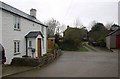
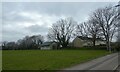
Trembraze
The junction in the centre of a small hamlet northeast of Liskeard, at the eastern edge of the square.
Image: © Derek Harper
Taken: 22 Jan 2009
0.11 miles
2
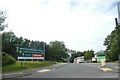
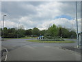
Carlton Way, Liskeard
Access road from the bypass to a growing (in 2021) housing estate
Image: © David Smith
Taken: 6 Jul 2021
0.14 miles
3
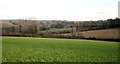
Farmland north of Liskeard
Looking east from the B3254 at Trevecca Cottages, further to the right than Image, with houses at Tremblaze visible.
Image: © Derek Harper
Taken: 24 Jan 2015
0.17 miles
4
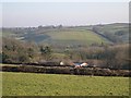
View from Trevecca Cottages
Looking east over Tregay Farm to the hillsides and valleys in the next grid square.
Image: © Tony Atkin
Taken: 28 Dec 2005
0.18 miles
5
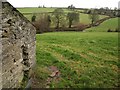
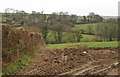
Tregay
The farm buildings seen from the lane west of Trembraze. The substantial collection of farm buildings are at the head of the side valley shown in Image
Image: © Derek Harper
Taken: 22 Jan 2009
0.18 miles
6
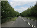
The A390, Charter Way at Callington Road, Liskeard
Image: © Ian S
Taken: 25 May 2013
0.19 miles
7
Lane to Welltown
Trees along the tiny dead-end lane to the hamlet shown in Image crosses a small valley. Seen looking along the very western edge of the square from beside an outbuilding at Trembraze, on the lane to Hendra Bridge.
Image: © Derek Harper
Taken: 22 Jan 2009
0.22 miles
8
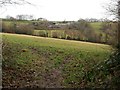
Sports ground by B3254 north of Liskeard
Image: © David Smith
Taken: 17 Mar 2022
0.24 miles
10
Towards Welltown
Looking across a side valley of the River Seaton, from the lane east of Trembraze. Welltown is a tiny hamlet of about four houses.
Image: © Derek Harper
Taken: 22 Jan 2009
0.24 miles