1
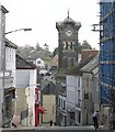
Liskeard town centre
The town of Liskeard is built at the head of a steep valley and spreads out onto the plateau above. This photograph looks east across the town centre valley. The Guildhall Clocktower rises above the level of the surrounding buildings.
Image: © Tony Atkin
Taken: 9 Apr 2004
0.04 miles
2
Castle Park, Liskeard
A green space on the eastern side of the town.
Image: © Humphrey Bolton
Taken: 9 Mar 2001
0.09 miles
3
Old Wayside Cross - moved
Tencreek Cross, old head, shaft and base, Langdon EC No. 62 by the churchyard path, in parish of Liskeard (Caradon District), by the South East corner of the Church of St Martin, on well cut grass.
Surveyed
Milestone Society National ID: CWCN_LIS03
Image: © Alan Rosevear
Taken: 25 Sep 2009
0.12 miles
4
Leper Window at St Martin's Church
This small window is known locally as the Leper Window situated at the west end of the north aisle and of a type known as 'low side windows'. It is believed that the sacrament could be administered to leprosy sufferers, who would not have to enter the main church building. Whilst locals firmly believe this to be true, some doubt exists as close by at Maudlin Farm, now a retail park and supermarket complex, was a Leper Hospital which had its own chapel. Enquiries at the church however will direct you to the window which must have served a very specific purpose due to its size and close proximity to the outside ground level.
Image: © Eric Foster
Taken: 7 Aug 2011
0.12 miles
5
St Martins Church, Liskeard
Image: © Roger A Smith
Taken: 11 Feb 2014
0.12 miles
6
Bay Tree Hill looking towards St Martin's Church
Image: © Paul Barnett
Taken: 24 Feb 2014
0.12 miles
7
Liskeard - St Martin's Church
Image: © Colin Park
Taken: 13 Aug 2014
0.12 miles
8
Old Wayside Cross - moved to St Martin's churchyard, Liskeard Parish
Culverland Cross, old head, shaft & base, Langdon EC No. 61 by the churchyard path, in parish of Liskeard (Caradon District), by the North West wall of the tower of the Church of St Martin, on well cut grass.
Surveyed
Milestone Society National ID: CWCN_LIS02
Image: © Alan Rosevear
Taken: 25 Sep 2009
0.13 miles
9
External view of Leper Window at St Martins Church
The outside of the Leper Window at St Martins Church, now like all the stained glass windows of the church protected by steel mesh and anti vandal paint. Below the window is a small holy water stoup which lends credence to the belief that this window existed for the giving of the sacrament to persons not able to be inside the church itself.
Image: © Eric Foster
Taken: 7 Aug 2011
0.13 miles
10
Urban landscape in Liskeard
Taken from the end of Fore Street. St Martin's church in the background.
Image: © Dr Neil Clifton
Taken: 30 Mar 2009
0.13 miles


