IMAGES TAKEN NEAR TO
Newport Street, PLYMOUTH, PL1 3QG
Introduction
This page details the photographs taken nearby to Newport Street, PL1 3QG by members of the Geograph project.
The Geograph project started in 2005 with the aim of publishing, organising and preserving representative images for every square kilometre of Great Britain, Ireland and the Isle of Man.

There are currently over 7.5m images from over14,400 individuals and you can help contribute to the project by visiting https://www.geograph.org.uk
Image Map
Images are licensed for reuse under creativecommons.org/licenses/by-sa/2.0
Notes
- Clicking on the map will re-center to the selected point.
- The higher the marker number, the further away the image location is from the centre of the postcode.
Image Listing (268 Images Found)
Images are licensed for reuse under creativecommons.org/licenses/by-sa/2.0
Image
Details
Distance
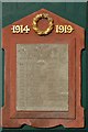
5
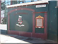
War Memorial - The Great War
The Regent Brewery stood at the junction of Chapel Street (now the lower part of Durnford Street) and Union Street just before the Stonehouse Bridge ("Ha’-penny toll bridge"). The buildings were erected in 1889 and became part of the Plymouth Breweries group in 1891.
As a large employer in the area, it was inevitable that many of its men served in the Great War (WWI) and the loss of lives was recorded on a concrete tablet originally located on the wall of the ‘Brewery Tap’ Public House attached to the Regent Brewery.
In 2002 the tablet was rescued and restored and is now set on the only remaining wall of the old Anchor Brewery building together with the lettering 'East Stonehouse' and the colourful Earls of Mount Edgcombe's coat-of-arms. At the time of the Great War, the Anchor Brewery building was part of the Plymouth Breweries Group which is the "Company" referred to in the memorial plaque.
In memory of the following employees of this Company who during the Great War gave their lives in the service of their country:
Sgt S Parsons 6th Dragoon Guards
Sgt T Ferris Devon Regt
Pte S Jones ditto
Pte J Rowe ditto
Pte E G Williams ditto
Pte H Hawswell Royal Fusiliers
Pte W Smith ditto
Pte C Finch Worcs Regt
Pte E Rodd D. C. L. I.
Pte J Chapman Northants Regt.
Pte J Moore Middlesex Reg
Pte A L Mitchell Cameron Highrs
Cpl H Rundle ditto
Pte V J Sherwood Machine Gun Corps
Image
Image: © Colin Vosper
Taken: 10 Mar 2010
0.02 miles
6
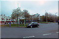
On the A 374
Roundabout at Stonehouse.
Image: © Robert Ashby
Taken: 22 Apr 2014
0.02 miles
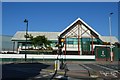
8
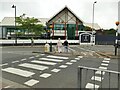
Approach to Stonehouse Bridge
The road going off centre left of the photo, where the white van is, is Stonehouse Bridge which was formerly was a toll bridge known as 'ha'penny' bridge. Now it is the route of the A374 through Plymouth and is a busy and main highway. There is definitely a need for the pedestrian crossings on the approach roads here.
There is one relic of significance barely visible which is the memorial to those of the old brewery company who lost their lives in the 'Great War 1914 - 1919' ... the First World War. The wall containing the memorial can just be seen between the belisha beacon and the lamp post to the left of centre. The wall is now alongside the premises of the lucky yacht and motor boat builders ~ 'Princess Yachts'. Image
At the centre of the photo, but difficult to seen, is a small alleyway beside the south side of the bridge limestone abutments giving public access down to the water of the creek. Image
Image: © Colin Vosper
Taken: 10 Mar 2010
0.02 miles
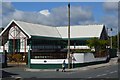
9

The Brewery Tap, Durnford Street
A Marston's pub, and this is not in any real sense the brewery's taproom. Formerly the Diamond Queen Image
Image: © Stephen Craven
Taken: 28 Jun 2023
0.02 miles
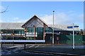
10
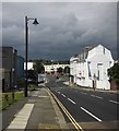
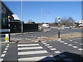
Durnford Street, Stonehouse
The buildings on the right are shown in Image The road is approaching a roundabout at the junction with the A374 at Stonehouse Bridge.
Image: © Derek Harper
Taken: 1 Aug 2015
0.03 miles