IMAGES TAKEN NEAR TO
Caroline Place, PLYMOUTH, PL1 3PS
Introduction
This page details the photographs taken nearby to Caroline Place, PL1 3PS by members of the Geograph project.
The Geograph project started in 2005 with the aim of publishing, organising and preserving representative images for every square kilometre of Great Britain, Ireland and the Isle of Man.

There are currently over 7.5m images from over14,400 individuals and you can help contribute to the project by visiting https://www.geograph.org.uk
Image Map
Images are licensed for reuse under creativecommons.org/licenses/by-sa/2.0
Notes
- Clicking on the map will re-center to the selected point.
- The higher the marker number, the further away the image location is from the centre of the postcode.
Image Listing (423 Images Found)
Images are licensed for reuse under creativecommons.org/licenses/by-sa/2.0
Image
Details
Distance
1
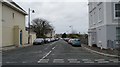
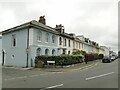
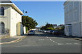
10 - 19, Caroline Place
Grade II listed. https://britishlistedbuildings.co.uk/101130011-nos10-19-caroline-place-including-forecourt-walls-and-railings-st-peter-and-the-waterfront-ward
Image: © N Chadwick
Taken: 5 Aug 2018
0.01 miles
2
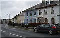
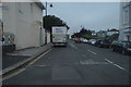
10, Millbay Rd
Grade II listed. http://www.britishlistedbuildings.co.uk/en-473225-numbers-10-19-including-forecourt-walls-
Image: © N Chadwick
Taken: 28 Nov 2015
0.01 miles
4
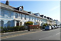
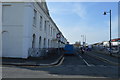
10-19 Caroline Place
This terrace of houses of 1835 (partially rebuilt after WW2) is listed grade II as 'an elegant early-C19 terrace that is well articulated by neo-classical detailing and projecting porches; as part of the development Stonehouse as fashionable suburb which had increased in importance as a military centre'. List entry 1130011.
Image: © Stephen Craven
Taken: 28 Jun 2023
0.02 miles
9
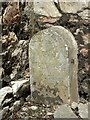
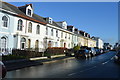
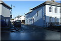
Old Boundary Marker on North Quay, Plymouth
Municipal Boundary Marker between buttresses and against a stone wall on the north side of North Quay, behind the buildings on the south side of Millbay Road. Erected by East Stonehouse Local Board of Health.
Milestone Society National ID: DV_ESBS01pb
Image: © T Jenkinson
Taken: 16 May 2012
0.03 miles