IMAGES TAKEN NEAR TO
Lanreath, LOOE, PL13 2PD
Introduction
This page details the photographs taken nearby to PL13 2PD by members of the Geograph project.
The Geograph project started in 2005 with the aim of publishing, organising and preserving representative images for every square kilometre of Great Britain, Ireland and the Isle of Man.

There are currently over 7.5m images from over14,400 individuals and you can help contribute to the project by visiting https://www.geograph.org.uk
Image Map
Images are licensed for reuse under creativecommons.org/licenses/by-sa/2.0
Notes
- Clicking on the map will re-center to the selected point.
- The higher the marker number, the further away the image location is from the centre of the postcode.
Image Listing (11 Images Found)
Images are licensed for reuse under creativecommons.org/licenses/by-sa/2.0
Image
Details
Distance
1
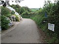
Trevollard: Track to Carwen
This lane is a no-through-road which leads to Carwen. The sign informs us that Carwen Farm is a "Supplier of top quality Farm Assured Milk". Various hues of hydrangea can be seen on the left side of the lane here.
Image: © Rob Farrow
Taken: 17 Aug 2007
0.02 miles
2
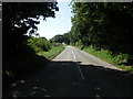
The road south-west of Trevollard.
Image: © Richard Williams
Taken: 22 Aug 2007
0.04 miles
3
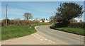
Lower Trevollard Crossroads
Image: © Derek Harper
Taken: 25 Mar 2017
0.05 miles
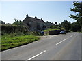
4
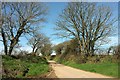
Lane from Lower Trevollard Crossroads
The lane leads along the crest of the Trebant Water valley and then drops to a farm called Trebantwater and Trebant Bridge.
Image: © Derek Harper
Taken: 25 Mar 2017
0.10 miles
5
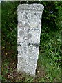
Old Milestone at Lower Trevollard crossroads
Carved stone post by the UC road, in parish of LANREATH (CARADON District), Lower Trevollard, West corner of crossroads, on West side of road. Erected by the parish in the 19th century.
Inscription reads:-
: FOY / IV : : LISK / XI : : LOS / V :
Carved benchmark recorded.
Grade II listed.
List Entry Number: 1396598 https://historicengland.org.uk/listing/the-list/list-entry/1396598
Milestone Society National ID: CW_FYLS04.
Image: © Rosy Hanns
Taken: 25 May 2019
0.11 miles
6
Milestone, Lower Trevollard Crossroads
Also seen in Image "An C18 milestone, square in section, with a projecting cap and approximately one metre in height ... inscribed in Sans Serif capitals: 'FOY / IV' 'LISK / XI' 'LOS / V' " https://www.historicengland.org.uk/listing/the-list/list-entry/1396598 .
Image: © Derek Harper
Taken: 25 Mar 2017
0.11 miles
7
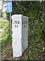
Old Milestone at Lower Trevollard crossroads
Carved stone post by the UC road, in parish of LANREATH (CARADON District), Lower Trevollard, North West corner of crossroads, on West side of road. Erected by the parish in the 19th century.
Inscription reads:-
: FOY / IV : : LISK / XI : : LOS / V :
Grade II Listed. List Entry Number: 1396598
https://historicengland.org.uk/listing/the-list/list-entry/1396598
Milestone Society National ID: CW_FYLS04.
Image: © Ian Thompson
Taken: 1 Oct 2002
0.11 miles
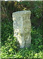
9
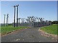
Electricity Sub Station near Trevollard.
Image: © Richard Williams
Taken: 22 Aug 2007
0.13 miles
10

Lane to Treire Farm
From its beginning at Lower Trevollard Crossroads, with an C18 milestone described at https://www.historicengland.org.uk/listing/the-list/list-entry/1396598 on the right.
Image: © Derek Harper
Taken: 25 Mar 2017
0.14 miles