IMAGES TAKEN NEAR TO
Millendreath Holiday Village, LOOE, PL13 1PF
Introduction
This page details the photographs taken nearby to Millendreath Holiday Village, PL13 1PF by members of the Geograph project.
The Geograph project started in 2005 with the aim of publishing, organising and preserving representative images for every square kilometre of Great Britain, Ireland and the Isle of Man.

There are currently over 7.5m images from over14,400 individuals and you can help contribute to the project by visiting https://www.geograph.org.uk
Image Map (Loading...)


Getting Data...Please wait
Leaflet Map data © OpenStreetMap
Images are licensed for reuse under creativecommons.org/licenses/by-sa/2.0
Notes
- Clicking on the map will re-center to the selected point.
- The higher the marker number, the further away the image location is from the centre of the postcode.
Image Listing (18 Images Found)
Images are licensed for reuse under creativecommons.org/licenses/by-sa/2.0
Image
Details
Distance
1
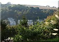
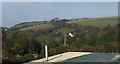
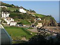
Millendreath Holiday Village
Chalets on the western slopes of the Millendreath valley, seen from the South West Coast Path on the opposite side.
Image: © Derek Harper
Taken: 2 Oct 2011
0.12 miles
2
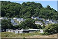
Millendreath Holiday Village
This is a fairly idyllic setting but is probably better for morning people, that steep slope faces due east. It is only a short walk to the beach but don't expect any facilities when you get there!
Image: © Tony Atkin
Taken: 17 Jul 2006
0.12 miles
3
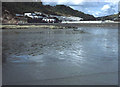
Millendreath
From the beach looking north up the narrow valley to the holiday village chalets.
http://www.chycor.co.uk/apartments/millendreath-millsun/
Image: © Trevor Rickard
Taken: Unknown
0.18 miles
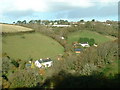
4
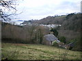
Millendreath from the road towards Bucklawren
Millendreath village is hard to picture in its entirety, due to its being in a deep & wooded valley. This photo is taken from the north-northeast, heading up the steep, narrow lane that leads to Bucklawren Farm.
Image: © Richard Law
Taken: 26 Dec 2008
0.18 miles
5
Valley side above Millendreath
Looking up the valley over the roof of Image from the South West Coast Path, with Polliscourt House on the steep lane to Bucklawren.
Image: © Derek Harper
Taken: 2 Oct 2011
0.19 miles
6
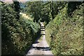
Steep Lane to Millendreath
Grass growing in the centre of the road is a good indication that this lane is very little used.
Image: © Tony Atkin
Taken: 17 Jul 2006
0.19 miles
7
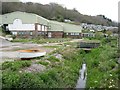
Churchabridge, Millendreath Valley, Looking North
Small hamlet and Caravan Site near Looe.
Image: © Paul Jenkins
Taken: Unknown
0.19 miles
8
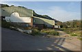
Former club, Millendreath
See Image; this building is due to be demolished and replaced with a new multi-purpose clubhouse and reception office building. The coast path begins its climb to Plaidy on the left.
Image: © Derek Harper
Taken: 2 Oct 2011
0.20 miles
9
Disused building, Millendreath
A disused building above the Millendreath beach. Not sure was this building was but it is now shut up and fenced off.
Image: © Philip Halling
Taken: 16 Apr 2011
0.22 miles
10
Millendreath
From the South West Coast Path, with Image in the immediate foreground left, and some of the houses shown in Image
Image: © Derek Harper
Taken: 2 Oct 2011
0.22 miles