IMAGES TAKEN NEAR TO
Barbican Hill, LOOE, PL13 1AF
Introduction
This page details the photographs taken nearby to Barbican Hill, PL13 1AF by members of the Geograph project.
The Geograph project started in 2005 with the aim of publishing, organising and preserving representative images for every square kilometre of Great Britain, Ireland and the Isle of Man.

There are currently over 7.5m images from over14,400 individuals and you can help contribute to the project by visiting https://www.geograph.org.uk
Image Map
Images are licensed for reuse under creativecommons.org/licenses/by-sa/2.0
Notes
- Clicking on the map will re-center to the selected point.
- The higher the marker number, the further away the image location is from the centre of the postcode.
Image Listing (80 Images Found)
Images are licensed for reuse under creativecommons.org/licenses/by-sa/2.0
Image
Details
Distance
6
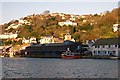
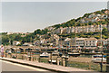
East Looe in the late afternoon sunlight
The tide is high and the dark building in shadow is the fish quay.
Image: © Tony Atkin
Taken: 13 Nov 2005
0.15 miles
7
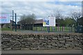
Looe Children?s Centre, Barbican, Looe
On this evening the centre was the venue for Looe's cinema by the sea.
Image: © Trevor Harris
Taken: 1 Apr 2017
0.15 miles
10
East Looe and Shutta
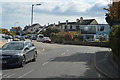
Here the busy A387 crosses the seven-arched Victorian bridge over the River Looe, and gives access to East Looe and Shutta on the hilltop above the river.
Image: © Stuart Logan
Taken: Unknown
0.19 miles