IMAGES TAKEN NEAR TO
Citadel Road, PLYMOUTH, PL1 2QA
Introduction
This page details the photographs taken nearby to Citadel Road, PL1 2QA by members of the Geograph project.
The Geograph project started in 2005 with the aim of publishing, organising and preserving representative images for every square kilometre of Great Britain, Ireland and the Isle of Man.

There are currently over 7.5m images from over14,400 individuals and you can help contribute to the project by visiting https://www.geograph.org.uk
Image Map
Images are licensed for reuse under creativecommons.org/licenses/by-sa/2.0
Notes
- Clicking on the map will re-center to the selected point.
- The higher the marker number, the further away the image location is from the centre of the postcode.
Image Listing (1715 Images Found)
Images are licensed for reuse under creativecommons.org/licenses/by-sa/2.0
Image
Details
Distance

3
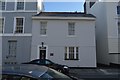
30&31 Athenaeum Street, Plymouth
A pair of houses, attributed to John Foulston who was responsible for the development of terraces and villas on The Hoe in the first half of the 19th century. Listed Grade II.
Image: © Alan Murray-Rust
Taken: 29 Jun 2023
0.01 miles
4
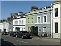
26-29 Athenaeum Street, Plymouth
Two pairs of villas on the east side of the street, each pair with a combined timber porch. The nearest house (no.29) retains its original rusticated stucco. Built c.1829 by John Foulston as part of his planned development of the area, Listed Grade II together with nos 22-25 https://www.geograph.org.uk/photo/7535209.
Image: © Alan Murray-Rust
Taken: 29 Jun 2023
0.01 miles
5
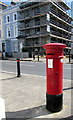
Victorian pillarbox on a Plymouth corner
On the corner of Atheneum Street and Citadel Road.
Image: © Jaggery
Taken: 14 Jul 2018
0.01 miles
6

Pillar box, ref PL1 18D, Citadel Road, Plymouth
Standard late Victorian pillar box with VR cipher. See https://www.geograph.org.uk/photo/7535205 for location.
Image: © Alan Murray-Rust
Taken: 29 Jun 2023
0.01 miles
7
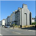
256-262 Citadel Road, Plymouth
Four villas, Listed Grade II as a set, which originally formed a continuous terrace between the two side roads; the end one demolished and others rebuilt following WWII bomb damage. Part of an important planned group of terraces and villas by Foulston and his pupil Wightwick on the Hoe, a scheme which placed Plymouth in the forefront of town planning in the early/mid C19.
Image: © Alan Murray-Rust
Taken: 29 Jun 2023
0.02 miles
10
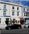
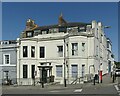
Westwinds and The Lamplighter, Citadel Road, Plymouth
Two of many guesthouses is this part of Plymouth.
Image: © Jaggery
Taken: 14 Jul 2018
0.03 miles