IMAGES TAKEN NEAR TO
Grassmere Way, SALTASH, PL12 6XF
Introduction
This page details the photographs taken nearby to Grassmere Way, PL12 6XF by members of the Geograph project.
The Geograph project started in 2005 with the aim of publishing, organising and preserving representative images for every square kilometre of Great Britain, Ireland and the Isle of Man.

There are currently over 7.5m images from over14,400 individuals and you can help contribute to the project by visiting https://www.geograph.org.uk
Image Map
Images are licensed for reuse under creativecommons.org/licenses/by-sa/2.0
Notes
- Clicking on the map will re-center to the selected point.
- The higher the marker number, the further away the image location is from the centre of the postcode.
Image Listing (33 Images Found)
Images are licensed for reuse under creativecommons.org/licenses/by-sa/2.0
Image
Details
Distance
1
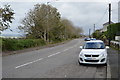
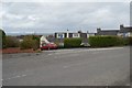
Pillmere Estate, Saltash
Pillmere Estate, Saltash. An estate of approx 1200 houses when complete crammed between the A38 and New Road, Saltash, Cornwall.
Image: © Kevin Hale
Taken: 17 Apr 2006
0.05 miles
2
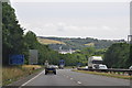
Saltash : The A38
Heading along the A38 as it heads across the northern side of Saltash.
Image: © Lewis Clarke
Taken: 17 Jul 2015
0.14 miles
3
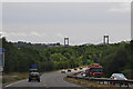
Saltash : The A38
The A38 heading through Saltash and towards the Tamar Bridge.
Image: © Lewis Clarke
Taken: 17 Jul 2015
0.14 miles
4
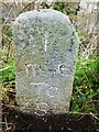
Old Milestone by New Road, Burraton
Carved stone post by the UC "New Road", in parish of SALTASH (CARADON District), Burraton, New Road, opposite bungalows, behind concrete post and wire fence, on North side of road. Saltash 'S' stone, erected by the Saltash turnpike trust in the 19th century.
Inscription reads:-
I
mile
To
S
Carved bench mark and rivet on top.
Grade II listed.
List Entry Number: 1391980 https://historicengland.org.uk/listing/the-list/list-entry/1391980
Milestone Society National ID: CW_SHLK01.
Image: © Rosy Hanns
Taken: 20 Mar 2019
0.16 miles
5
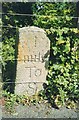
Old Milestone by New Road, Burraton
Carved stone post by the UC "New Road", in parish of SALTASH (CARADON District), Burraton, New Road, opposite bungalows, behind concrete post and wire fence, on North side of road. Saltash 'S' stone, erected by the Saltash turnpike trust in the 19th century.
Inscription reads:-
I
mile
To
S
Grade II Listed. List Entry Number:1391980
https://historicengland.org.uk/listing/the-list/list-entry/1391980
Milestone Society National ID: CW_SHLK01.
Image: © Ian Thompson
Taken: 1 May 2006
0.16 miles
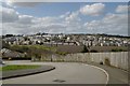
7
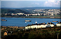
River Tamar from Saltash
View taken from the "old" A38 before the Saltash Tunnel and the 1980's housing were built. The row of houses in the foreground is Brookdown Terrace. Ernesettle on the far, Devon, side of the Tamar. Dartmoor on the horizon.
Image: © Crispin Purdye
Taken: Unknown
0.18 miles
8
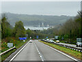
A38 towards Saltash and Plymouth
The stretch of water ahead is the Hamoaze, the estuarine stretch of the tidal River Tamar, between its confluence with the River Lynher and Plymouth Sound.
Image: © David Dixon
Taken: 13 Apr 2022
0.18 miles