IMAGES TAKEN NEAR TO
Landulph, SALTASH, PL12 6QQ
Introduction
This page details the photographs taken nearby to PL12 6QQ by members of the Geograph project.
The Geograph project started in 2005 with the aim of publishing, organising and preserving representative images for every square kilometre of Great Britain, Ireland and the Isle of Man.

There are currently over 7.5m images from over14,400 individuals and you can help contribute to the project by visiting https://www.geograph.org.uk
Image Map
Images are licensed for reuse under creativecommons.org/licenses/by-sa/2.0
Notes
- Clicking on the map will re-center to the selected point.
- The higher the marker number, the further away the image location is from the centre of the postcode.
Image Listing (5 Images Found)
Images are licensed for reuse under creativecommons.org/licenses/by-sa/2.0
Image
Details
Distance
1
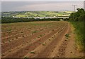
Potato field near Wayton
Footpath 610/9/1 runs along the edge of this field, formerly pasture. Ahead is the Tamar estuary, with sunlit Devon beyond.
Image: © Derek Harper
Taken: 7 Jun 2013
0.04 miles
2
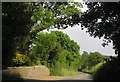
Road to Landulph Cross
The road passes the entrance to a house at Wayton.
Image: © Derek Harper
Taken: 7 Jun 2013
0.08 miles
3
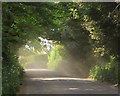
Road at Wayton
Sunshine filters through the dust raised by the passage of cars on this quite busy road.
Image: © Derek Harper
Taken: 7 Jun 2013
0.11 miles
4
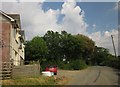
Road past Wayton House
With Wayton Cottages on the left. The road leads to Landulph.
Image: © Derek Harper
Taken: 7 Jun 2013
0.17 miles
5
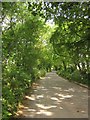
Tree-lined road, Wayton
A little further along the road shown in Image
Image: © Derek Harper
Taken: 7 Jun 2013
0.25 miles