IMAGES TAKEN NEAR TO
SALTASH, PL12 6DQ
Introduction
This page details the photographs taken nearby to PL12 6DQ by members of the Geograph project.
The Geograph project started in 2005 with the aim of publishing, organising and preserving representative images for every square kilometre of Great Britain, Ireland and the Isle of Man.

There are currently over 7.5m images from over14,400 individuals and you can help contribute to the project by visiting https://www.geograph.org.uk
Image Map (Loading...)


Getting Data...Please wait
Leaflet Map data © OpenStreetMap
Images are licensed for reuse under creativecommons.org/licenses/by-sa/2.0
Notes
- Clicking on the map will re-center to the selected point.
- The higher the marker number, the further away the image location is from the centre of the postcode.
Image Listing (149 Images Found)
Images are licensed for reuse under creativecommons.org/licenses/by-sa/2.0
Image
Details
Distance
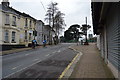
1
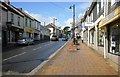
Saltash High Street
Sunday morning looking up the high street away from the bridges.
Image: © roger geach
Taken: 4 Apr 2010
0.03 miles
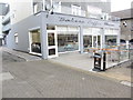
2
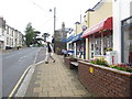
Retail Shops, Fore Street
Looking towards Callington Road.
Image: © Peter Holmes
Taken: 7 May 2014
0.05 miles
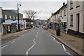
3
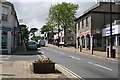
Looking up Fore Street
Looking uphill towards the top of Fore Street. Normally there are a lot of shoppers on the street but not on a Sunday.
Image: © Tony Atkin
Taken: 25 May 2008
0.05 miles
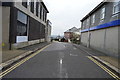
4
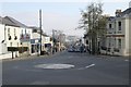
Fore Street, Saltash
Saltash's main street, Fore Street, viewed from Victoria Gardens, looking downhill towards the River Tamar, and the world famous Royal Albert Railway Bridge and Tamar Road Bridge.
Image: © Kevin Hale
Taken: 16 Feb 2008
0.05 miles