IMAGES TAKEN NEAR TO
Brenton Terrace, SALTASH, PL12 5HS
Introduction
This page details the photographs taken nearby to Brenton Terrace, PL12 5HS by members of the Geograph project.
The Geograph project started in 2005 with the aim of publishing, organising and preserving representative images for every square kilometre of Great Britain, Ireland and the Isle of Man.

There are currently over 7.5m images from over14,400 individuals and you can help contribute to the project by visiting https://www.geograph.org.uk
Image Map (Loading...)


Getting Data...Please wait
Leaflet Map data © OpenStreetMap
Images are licensed for reuse under creativecommons.org/licenses/by-sa/2.0
Notes
- Clicking on the map will re-center to the selected point.
- The higher the marker number, the further away the image location is from the centre of the postcode.
Image Listing (30 Images Found)
Images are licensed for reuse under creativecommons.org/licenses/by-sa/2.0
Image
Details
Distance
2
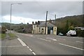
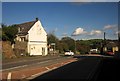
A38 Tideford, looking eastward
The A38 at Tideford in south east Cornwall. Tideford is named after a ford here over the river Tiddy. For a view west, see this image Image The road leading from the left of the picture leads to Tideford Cross Image
Image: © Kevin Hale
Taken: 1 Jan 2006
0.06 miles
3

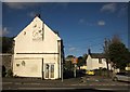
Post Box, Tideford
Post Box on the Post Office at Tideford, south east Cornwall. This can be seen in the wall in image Image
Image: © Kevin Hale
Taken: 1 Jan 2006
0.06 miles
4
A38 Tideford, looking westward
The A38 cutting through the village of Tideford in south east Cornwall. The corresponding view eastwards is Image The road leading right from the picture in front of the Post Office leads to Tideford Cross in Image
Image: © Kevin Hale
Taken: 1 Jan 2006
0.06 miles
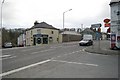
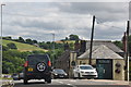
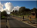
6
A38 at Tideford
The crossroads shown in Image] from the west.
Image: © Derek Harper
Taken: 4 Nov 2013
0.09 miles
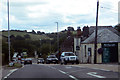
7
Crossroads, Tideford
Roadwise, the focal point of the village, but unfortunately with the A38 ploughing through the middle. Opposite is Church Road.
Image: © Derek Harper
Taken: 4 Nov 2013
0.09 miles
8
Tideford : Quay Road, A38
The A38 heads through the town of Tideford.
Image: © Lewis Clarke
Taken: 17 Jul 2015
0.09 miles
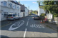
10
A38 entering Tideford
With the shelter on the other side where I waited for a bus at the end of walk to here a few weeks earlier.
Image: © Derek Harper
Taken: 4 Nov 2013
0.10 miles