IMAGES TAKEN NEAR TO
Landrake, SALTASH, PL12 5ES
Introduction
This page details the photographs taken nearby to PL12 5ES by members of the Geograph project.
The Geograph project started in 2005 with the aim of publishing, organising and preserving representative images for every square kilometre of Great Britain, Ireland and the Isle of Man.

There are currently over 7.5m images from over14,400 individuals and you can help contribute to the project by visiting https://www.geograph.org.uk
Image Map
Images are licensed for reuse under creativecommons.org/licenses/by-sa/2.0
Notes
- Clicking on the map will re-center to the selected point.
- The higher the marker number, the further away the image location is from the centre of the postcode.
Image Listing (2 Images Found)
Images are licensed for reuse under creativecommons.org/licenses/by-sa/2.0
Image
Details
Distance
1
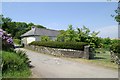
Treluggan Manor
Treluggan Manor, near St Erney, south east Cornwall.
Image: © Kevin Hale
Taken: 10 Jun 2006
0.19 miles
2
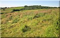
Towards Berry Hill
Looking to the right from the same point as Image The woodland is in Image and is around the disused Buttery Quarry.
Image: © Derek Harper
Taken: 14 Jun 2014
0.19 miles