IMAGES TAKEN NEAR TO
Church Street, SALTASH, PL12 5ER
Introduction
This page details the photographs taken nearby to Church Street, PL12 5ER by members of the Geograph project.
The Geograph project started in 2005 with the aim of publishing, organising and preserving representative images for every square kilometre of Great Britain, Ireland and the Isle of Man.

There are currently over 7.5m images from over14,400 individuals and you can help contribute to the project by visiting https://www.geograph.org.uk
Image Map
Images are licensed for reuse under creativecommons.org/licenses/by-sa/2.0
Notes
- Clicking on the map will re-center to the selected point.
- The higher the marker number, the further away the image location is from the centre of the postcode.
Image Listing (40 Images Found)
Images are licensed for reuse under creativecommons.org/licenses/by-sa/2.0
Image
Details
Distance
1
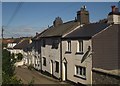
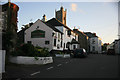
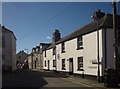
Houses on Church Street, Landrake
The further end of this terrace can be seen in Image], looking in the opposite direction.
Image: © Derek Harper
Taken: 10 Oct 2013
0.01 miles
2
Church of St Michael, Landrake
Another view of Image] from further east in the churchyard. http://list.english-heritage.org.uk/resultsingle.aspx?uid=1140553&searchtype=mapsearch
Image: © Derek Harper
Taken: 10 Oct 2013
0.01 miles
3
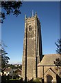
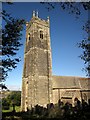
St Michael and All Angel?s Church, Landrake
The building of the 100ft Tower which is in three stages, buttressed on the square and finished with battlements and pinnacles commenced during the late 14th century taking nearly fifty years to complete.
Image: © Richard Rogerson
Taken: 29 Mar 2013
0.02 miles
4
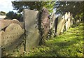
Gravestones, Landrake
In the churchyard of St Michael's church, with lettering highlighted by the autumn sun.
Image: © Derek Harper
Taken: 10 Oct 2013
0.03 miles
5
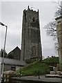
Church of St Michael, Landrake
A grade I listed building http://list.english-heritage.org.uk/resultsingle.aspx?uid=1140553&searchtype=mapsearch "with a tower 100 feet high which can be seen from far away" (Pevsner, 1951).
Image: © Derek Harper
Taken: 10 Oct 2013
0.03 miles
6
Church Street, Landrake
With the Bullers Arms, also seen at http://www.geograph.org.uk/search.php?i=44314028 , on the left, by the junction at The Square. The road forks higher up, with lanes leading to Poldrissick Quay and St Erney.
Image: © Derek Harper
Taken: 10 Oct 2013
0.03 miles
7
Last of the sun
Just before sunset the church tower catches the last rays of the sun while the Bullers Arms are in shadow. Landrake Village; this was once the main A38 Plymouth road,now bypassed but very busy.
Image: © roger geach
Taken: 14 Aug 2011
0.04 miles
8
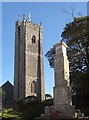
Church tower and war memorial, Landrake
A view from Tideford Road of the tower of Image] and the war memorial http://www.roll-of-honour.com/Cornwall/Landrake.html http://www.ukniwm.org.uk/server/show/conMemorial.41413/fromUkniwmSearch/1 .
Image: © Derek Harper
Taken: 10 Oct 2013
0.04 miles
9
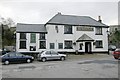
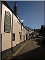
Bullers Arms, Landrake
The Bullers Arms, Landrake, lies on what used to be the main A38 road into Cornwall. Fortunately for the residents, the village was bypassed many years ago.
Image: © Kevin Hale
Taken: 1 Jan 2006
0.05 miles
10
Tideford Road, Landrake
From The Square, looking past the junction with Church Street (left).
Image: © Derek Harper
Taken: 10 Oct 2013
0.05 miles