IMAGES TAKEN NEAR TO
North Road, SALTASH, PL12 5EL
Introduction
This page details the photographs taken nearby to North Road, PL12 5EL by members of the Geograph project.
The Geograph project started in 2005 with the aim of publishing, organising and preserving representative images for every square kilometre of Great Britain, Ireland and the Isle of Man.

There are currently over 7.5m images from over14,400 individuals and you can help contribute to the project by visiting https://www.geograph.org.uk
Image Map (Loading...)


Getting Data...Please wait
Leaflet Map data © OpenStreetMap
Images are licensed for reuse under creativecommons.org/licenses/by-sa/2.0
Notes
- Clicking on the map will re-center to the selected point.
- The higher the marker number, the further away the image location is from the centre of the postcode.
Image Listing (43 Images Found)
Images are licensed for reuse under creativecommons.org/licenses/by-sa/2.0
Image
Details
Distance
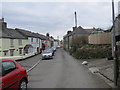
1
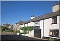
Houses on North Road, Landrake
Pound Farm, on the extreme left, is across the busy A38.
Image: © Derek Harper
Taken: 10 Oct 2013
0.02 miles
2
Landrake last of the sun
The junction of Tideford Road and School Road, Landrake, south east Cornwall. The sun is about to set so the shadows are very long. Most of the picture is in darkness.
Image: © roger geach
Taken: 14 Aug 2011
0.02 miles
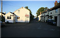
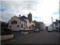
3
Foot of Church Street, Landrake
With The Square ahead, and the Bullers Arms on the right. North Road is the street across The Square.
Image: © Derek Harper
Taken: 10 Oct 2013
0.03 miles
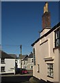
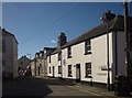
4
The Old Smithy, Landrake
Bearing the date 1520 on the facade, though unlisted. This is on Fore Street, close to The Square.
Image: © Derek Harper
Taken: 10 Oct 2013
0.03 miles
6
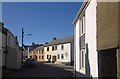
Fore Street, Landrake
Seen from School Road, passing the junction with New Road.
Image: © Derek Harper
Taken: 10 Oct 2013
0.03 miles
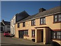
7
Tideford Road, Landrake
From The Square, looking past the junction with Church Street (left).
Image: © Derek Harper
Taken: 10 Oct 2013
0.03 miles
9
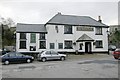
Bullers Arms, Landrake
The Bullers Arms, Landrake, lies on what used to be the main A38 road into Cornwall. Fortunately for the residents, the village was bypassed many years ago.
Image: © Kevin Hale
Taken: 1 Jan 2006
0.03 miles
10
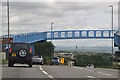
Landrake : The A38
The A38 heads through Landrake and underneath a footbridge.
Image: © Lewis Clarke
Taken: 17 Jul 2015
0.04 miles