IMAGES TAKEN NEAR TO
Longlands, SALTASH, PL12 4QQ
Introduction
This page details the photographs taken nearby to PL12 4QQ by members of the Geograph project.
The Geograph project started in 2005 with the aim of publishing, organising and preserving representative images for every square kilometre of Great Britain, Ireland and the Isle of Man.

There are currently over 7.5m images from over14,400 individuals and you can help contribute to the project by visiting https://www.geograph.org.uk
Image Map (Loading...)


Getting Data...Please wait
Leaflet Map data © OpenStreetMap
Images are licensed for reuse under creativecommons.org/licenses/by-sa/2.0
Notes
- Clicking on the map will re-center to the selected point.
- The higher the marker number, the further away the image location is from the centre of the postcode.
Image Listing (3 Images Found)
Images are licensed for reuse under creativecommons.org/licenses/by-sa/2.0
Image
Details
Distance
1
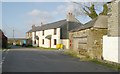
Longlands Cross, near Saltash
Longlands Cross, near Saltash. The left hand road leads to Elm Gate , the right hand one back to Saltash, whilst straight on goes to Trematon, and 'behind' you lies Trehan.
Image: © Kevin Hale
Taken: 10 Dec 2005
0.02 miles
2
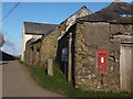
Farm buildings at the crossroads at Longlands
The wall-box is Victorian. The community was once large enough to have its own school, just to the south of the junction.
Image: © David Smith
Taken: 18 Mar 2012
0.02 miles
3
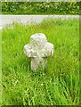
Old Wayside Cross by Trehan Villa, Saltash parish
Trehan Cross, old head and neck, Langdon EC No. 91 by the UC road, in parish of Saltash (Caradon District), by Trehan Villa on the ridge road across the top of the village, in triangular area of open grass at the junction.
Grade II listed.
List Entry Number: 1140387 https://historicengland.org.uk/listing/the-list/list-entry/1140387
Scheduled Monument.
List Entry Number: 1007968 https://historicengland.org.uk/listing/the-list/list-entry/1007968
Surveyed
Milestone Society National ID: CWCN_SAL03
Image: © Alan Rosevear
Taken: 22 May 2012
0.22 miles