IMAGES TAKEN NEAR TO
Sunwell Lane, TORPOINT, PL11 3EQ
Introduction
This page details the photographs taken nearby to Sunwell Lane, PL11 3EQ by members of the Geograph project.
The Geograph project started in 2005 with the aim of publishing, organising and preserving representative images for every square kilometre of Great Britain, Ireland and the Isle of Man.

There are currently over 7.5m images from over14,400 individuals and you can help contribute to the project by visiting https://www.geograph.org.uk
Image Map (Loading...)


Getting Data...Please wait
Leaflet Map data © OpenStreetMap
Images are licensed for reuse under creativecommons.org/licenses/by-sa/2.0
Notes
- Clicking on the map will re-center to the selected point.
- The higher the marker number, the further away the image location is from the centre of the postcode.
Image Listing (34 Images Found)
Images are licensed for reuse under creativecommons.org/licenses/by-sa/2.0
Image
Details
Distance
1
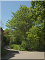
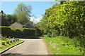
Sunwell Lane, St John
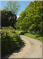
Several narrow valleys meet at St John, Sunwell Lane follows one westward from the junction where Image] was taken, towards Tregantle.
Image: © Derek Harper
Taken: 11 May 2019
0.02 miles
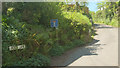
2
Signpost, St John
On a circle rather than a triangle of grass. In the background, St Johns Lane leaves the village towards Antony. There are houses along the lane but are well concealed by trees in this view.
Image: © Derek Harper
Taken: 11 May 2019
0.02 miles
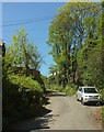
4
Jack's Lane, St John
A no through road, as the sign indicates, and a route with public access that turns into a public footpath. See also Image
Image: © Derek Harper
Taken: 11 May 2019
0.04 miles
5
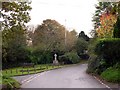
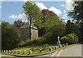
Church Lane, St John
The pyramid-capped stone posts can be recognised in Image Across the junction where that image was taken is Sunwell Lane Image The house on the corner is Bridge Cottage; the stream associated with the bridge flows on this side of the trees on the immediate right.
Image: © Derek Harper
Taken: 11 May 2019
0.04 miles
6
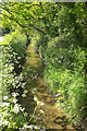
Stream, St John
The little stream, running towards the camera, is on the right of Church Lane, shown in Image
Image: © Derek Harper
Taken: 11 May 2019
0.05 miles
7
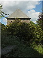
St John's church, St John
The west tower with its pyramidal roof https://historicengland.org.uk/listing/the-list/list-entry/1161834 .
Image: © Derek Harper
Taken: 11 May 2019
0.05 miles
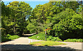
8
The Road outside the Church in St John
Ornamental garden trees and shrubs bring some extra colour to this November scene.
Image: © Tony Atkin
Taken: 6 Nov 2005
0.05 miles
9
Church Lane, St John
Image: © Derek Harper
Taken: 11 May 2019
0.06 miles
10
St John's church, St John
With the war memorial on the right. https://historicengland.org.uk/listing/the-list/list-entry/1161834 . Interesting that the pyramid-capped stone posts protecting the war memorial and its flowerbed reflect the pyramidal roof on the church tower.
Image: © Derek Harper
Taken: 11 May 2019
0.06 miles