IMAGES TAKEN NEAR TO
Portwrinkle, TORPOINT, PL11 3BT
Introduction
This page details the photographs taken nearby to PL11 3BT by members of the Geograph project.
The Geograph project started in 2005 with the aim of publishing, organising and preserving representative images for every square kilometre of Great Britain, Ireland and the Isle of Man.

There are currently over 7.5m images from over14,400 individuals and you can help contribute to the project by visiting https://www.geograph.org.uk
Image Map
Images are licensed for reuse under creativecommons.org/licenses/by-sa/2.0
Notes
- Clicking on the map will re-center to the selected point.
- The higher the marker number, the further away the image location is from the centre of the postcode.
Image Listing (65 Images Found)
Images are licensed for reuse under creativecommons.org/licenses/by-sa/2.0
Image
Details
Distance
1
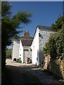
Coastguard cottages, Portwrinkle
Seen from Donkey Lane, the steep road at the west end of the village that was used by donkeys hauling carts of pilchards up from the harbour. Some of the coastguard cottages are now holiday homes.
Image: © Derek Harper
Taken: 2 Oct 2011
0.01 miles
2
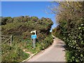
Coast path on Donkey Lane
The South West Coast Path turns off the steep hill above Portwrinkle to run behind gardens.
Image: © Derek Harper
Taken: 2 Oct 2011
0.03 miles
3
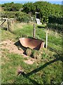
Broken trough, Portwrinkle
You wouldn't want to be in the same field with the animal that destroyed this. Fortunately, the South West Coast Path skirts it.
Image: © Derek Harper
Taken: 2 Oct 2011
0.03 miles
4
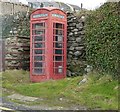
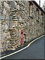
K6 Red Telephone call box, Portwrinkle
This surviving K6 style telephone call box on the bend of Donkey Lane in Portwrinkle looks to be in need of a fresh lick of paint, but is otherwise in very good condition.
Image: © Rob Farrow
Taken: 25 Jan 2014
0.04 miles
5
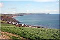
Portwrinkle, Rame Head and Whitesand bay
As seen from the coast road from Downderry.
Image: © roger geach
Taken: 6 Apr 2008
0.04 miles
6

Landmark near Portwrinkle
This small white structure looks a bit like the chimney of a troglodyte dwelling or a well-head. The Bungalow, up on the crest of the hill, is in Image View from the South West Coast Path.
Image: © Derek Harper
Taken: 2 Oct 2011
0.05 miles
7
Postbox, Fish Cellars, Portwrinkle
A postbox with the cypher GR set into the wall of Image As there is no Roman numeral (V or VI) I would assume that it dates from the earlier of these two Georges' reigns (1910-1936).
Image: © Rob Farrow
Taken: 25 Jan 2014
0.05 miles
8
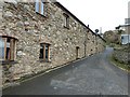
Fish Cellars, Portwrinkle
This row of cottages, known collectively as "Fish Cellars" are on an apparently unnamed dead-end lane running north off Finnygook Lane in Portwrinkle. They now comprise five dwellings.
Image: © Rob Farrow
Taken: 25 Jan 2014
0.05 miles
9
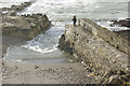
Portwrinkle Harbour
Two people stand at the end of the harbour wall watching the incoming tide gradually flood the beach. The harbour was at one time a centre for pilchard fishing.
Image: © Stephen McKay
Taken: 1 Jan 2018
0.06 miles
10

Harbour at Portwrinkle
A small harbour at Portwrinkle, Rame Head can be seen in the distance.
Image: © Philip Halling
Taken: 16 Apr 2011
0.07 miles