IMAGES TAKEN NEAR TO
Cedar Close, TORPOINT, PL11 2QH
Introduction
This page details the photographs taken nearby to Cedar Close, PL11 2QH by members of the Geograph project.
The Geograph project started in 2005 with the aim of publishing, organising and preserving representative images for every square kilometre of Great Britain, Ireland and the Isle of Man.

There are currently over 7.5m images from over14,400 individuals and you can help contribute to the project by visiting https://www.geograph.org.uk
Image Map
Images are licensed for reuse under creativecommons.org/licenses/by-sa/2.0
Notes
- Clicking on the map will re-center to the selected point.
- The higher the marker number, the further away the image location is from the centre of the postcode.
Image Listing (48 Images Found)
Images are licensed for reuse under creativecommons.org/licenses/by-sa/2.0
Image
Details
Distance
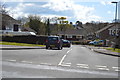
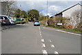
4
Trevol Road
Looking out of Torpoint, the road takes a dip through a valley before rising up the other side by HMS Raleigh.
Image: © Tony Atkin
Taken: 30 Oct 2005
0.06 miles
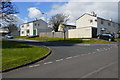
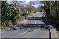
9
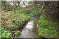
Normal tidal limit on stream, Torpoint
Looking left from the paving slabs shown in the stream in Image], past the stream confluence and across the point at which the map indicates the NTL for this stream.
Image: © Derek Harper
Taken: 27 Jan 2018
0.07 miles
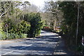
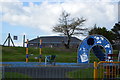
10
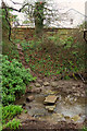
Stream crossing, Torpoint
There are several impromptu stream crossings beside footpath 639 7/1, this one leading into gardens.
Image: © Derek Harper
Taken: 27 Jan 2018
0.07 miles