IMAGES TAKEN NEAR TO
Lower Row, TORPOINT, PL10 1NN
Introduction
This page details the photographs taken nearby to Lower Row, PL10 1NN by members of the Geograph project.
The Geograph project started in 2005 with the aim of publishing, organising and preserving representative images for every square kilometre of Great Britain, Ireland and the Isle of Man.

There are currently over 7.5m images from over14,400 individuals and you can help contribute to the project by visiting https://www.geograph.org.uk
Image Map (Loading...)


Getting Data...Please wait
Leaflet Map data © OpenStreetMap
Images are licensed for reuse under creativecommons.org/licenses/by-sa/2.0
Notes
- Clicking on the map will re-center to the selected point.
- The higher the marker number, the further away the image location is from the centre of the postcode.
Image Listing (208 Images Found)
Images are licensed for reuse under creativecommons.org/licenses/by-sa/2.0
Image
Details
Distance
1
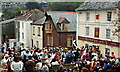
The Black Prince Flower Boat Procession
The Black Prince Procession is a Mayday custom in the villages of Millbrook, Kingsand and Cawsand. It takes place on Mayday bank holiday which this year (2008) is the 5th of May. The procession starts in Millbrook in the morning then moves to Kingsand and ends up on the beach at Cawsand where a model boat, The Black Prince, bedecked in flowers is floated out to sea to say goodbye to the harsh weather of Winter and welcome in the warm Summer weather. The procession is seen here gathering outside the Rising Sun pub in Kingsand.
Image: © Tony Atkin
Taken: 5 May 2008
0.01 miles
2
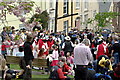
The Black Prince Procession gathering outside the Rising Sun
The procession is led by a model boat, The Black Prince, carried 'shoulder high' by ratings from the nearby HMS Raleigh. Others on the parade include town criers, morris dancers, musicians, shanty singers and local villagers and children, many wearing the traditional colours for the parade of red and white.
Image: © Tony Atkin
Taken: 5 May 2008
0.01 miles
3
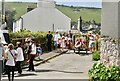
May Day Procession
Some of the junior May Queens in the procession.
Image: © Jay Pea
Taken: 7 May 2018
0.01 miles
4
Cottage, Kingsand
Seen from footpath 617 28/1, and perhaps next door to Image
Image: © Derek Harper
Taken: 8 Aug 2015
0.02 miles
5
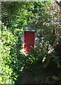
Red door, Kingsand
Seen from footpath 617 28/1, but not on it. The tiny path climbs round the north end of the village to meet Devonport Hill.
Image: © Derek Harper
Taken: 8 Aug 2015
0.02 miles
6
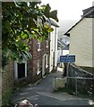
Heavitree Road, Kingsand
The two mid-C18 houses on the left are listed: http://list.historicengland.org.uk/resultsingle.aspx?uid=1329114&searchtype=mapsearch and (the rendered one) http://list.historicengland.org.uk/resultsingle.aspx?uid=1160882&searchtype=mapsearch .
Image: © Derek Harper
Taken: 8 Aug 2015
0.02 miles
7
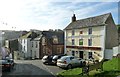
The Rising Sun on The Green, Kingsand
The road ahead is The Green in Kingsand. The pub is The Rising Sun, one of three pubs in Kingsand, the others being The Devonport and The Halfway House.
Image: © Rob Farrow
Taken: 25 Jan 2014
0.02 miles
8
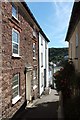
Heavitree Road, Kingsand
The twin (and seamlessly merged) villages of Kingsand and Cawsand have many narrow lanes, but the one seen here, Heavitree Road, is one of the narrowest. It runs downhill from Kingsway roughly parallel with The Green.
Image: © Rob Farrow
Taken: 25 Jan 2014
0.03 miles
9
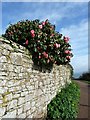
Camellias on the wall
A splash of pink colour as camellias bloom on a bush overhanging the wall near the entry to Minadew Brakes from Kingsway in Kingsand.
Image: © Rob Farrow
Taken: 25 Jan 2014
0.04 miles
10
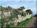
Wall beside entry to Minadew Brakes
This mellow old stone wall bedecked with ivy and camellias is just after the entry to the path across Minadew Brakes from a gate on Kingsway in Kingsand. For a closer view of the camellias see Image]
Image: © Rob Farrow
Taken: 25 Jan 2014
0.04 miles