IMAGES TAKEN NEAR TO
South Down Terrace, TORPOINT, PL10 1EX
Introduction
This page details the photographs taken nearby to South Down Terrace, PL10 1EX by members of the Geograph project.
The Geograph project started in 2005 with the aim of publishing, organising and preserving representative images for every square kilometre of Great Britain, Ireland and the Isle of Man.

There are currently over 7.5m images from over14,400 individuals and you can help contribute to the project by visiting https://www.geograph.org.uk
Image Map (Loading...)


Getting Data...Please wait
Leaflet Map data © OpenStreetMap
Images are licensed for reuse under creativecommons.org/licenses/by-sa/2.0
Notes
- Clicking on the map will re-center to the selected point.
- The higher the marker number, the further away the image location is from the centre of the postcode.
Image Listing (10 Images Found)
Images are licensed for reuse under creativecommons.org/licenses/by-sa/2.0
Image
Details
Distance
1
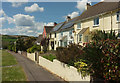
Southdown Terrace
Part of a terrace of six on Southdown Road, looking behind the camera in Image
Image: © Derek Harper
Taken: 11 May 2019
0.00 miles
2
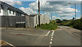
Junction on Southdown Road
Maker View Road, a cul-de-sac, turns off the no through road to Southdown from Millbrook.
Image: © Derek Harper
Taken: 11 May 2019
0.03 miles
3
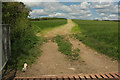
Track from Maker View Road
Leading from the cul-de-sac shown in Image] towards Sango Point. Kicking myself for not following it, but I would have been late picking up SWMBO, resulting in a kicking.
Image: © Derek Harper
Taken: 11 May 2019
0.06 miles
4
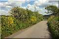
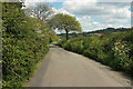
Southdown Road
The no through road to Southdown from Millbrook. Image] was taken further along the lane from the next corner.
Image: © Derek Harper
Taken: 11 May 2019
0.09 miles
5
Southdown Road
The no through road to Southdown from Millbrook. Masts at Southdown Marina can be glimpsed ahead.
Image: © Derek Harper
Taken: 11 May 2019
0.12 miles
6
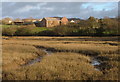
Insworke Barton
View across head of estuary to buildings marked on area of map called, Insworke Barton'.
Image: © BB
Taken: 25 Feb 2007
0.16 miles
7
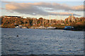
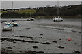
The view across the water from Foss point
Boats moored up across the water.
Image: © roger geach
Taken: 28 Nov 2012
0.23 miles
8
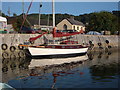
Fosse Quay - 'Coronette' just been launched
Maurice Griffiths design shallow draught yacht is ideal for navigating up drying estuaries such as Millbrook. There's not much drying that goes on here though as there's mud everywhere - including the metaphorical Millbrook mud that people like to try and wade through / get stuck in.
Image: © BB
Taken: 17 Jul 2006
0.23 miles
9
Tidal Creek at Anderton
View up the tidal creek at Anderton from Foss Point.
Image: © Philip Halling
Taken: 24 Feb 2009
0.23 miles
10
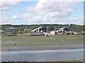
Boatyards at Southdown on the Insworke peninsula
Image: © Tony Atkin
Taken: 12 Aug 2005
0.24 miles