IMAGES TAKEN NEAR TO
Millpool Head, TORPOINT, PL10 1AW
Introduction
This page details the photographs taken nearby to Millpool Head, PL10 1AW by members of the Geograph project.
The Geograph project started in 2005 with the aim of publishing, organising and preserving representative images for every square kilometre of Great Britain, Ireland and the Isle of Man.

There are currently over 7.5m images from over14,400 individuals and you can help contribute to the project by visiting https://www.geograph.org.uk
Image Map (Loading...)


Getting Data...Please wait
Leaflet Map data © OpenStreetMap
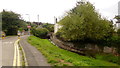
Images are licensed for reuse under creativecommons.org/licenses/by-sa/2.0
Notes
- Clicking on the map will re-center to the selected point.
- The higher the marker number, the further away the image location is from the centre of the postcode.
Image Listing (25 Images Found)
Images are licensed for reuse under creativecommons.org/licenses/by-sa/2.0
Image
Details
Distance
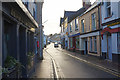
1
West Street, Millbrook
The Devon and Cornwall PH's lease is currently being advertised. (August 2018)
Two 'convenience stores' are three doors away from each other.
See a recent shot taken in January 2018; Image
Image: © Jonathan Billinger
Taken: 14 Aug 2018
0.06 miles
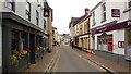
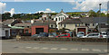
2
West Street, Millbrook
West Street is at the heart of the village, with the 17th century Devon & Cornwall Inn on the left.
Image: © Stephen McKay
Taken: 1 Jan 2018
0.06 miles
3
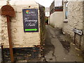
Signage, Middle Lane, Millbrook
The narrowest 'lane' the photographer has seen.
More like an alley or passage, really.
Image: © Jonathan Billinger
Taken: 14 Aug 2018
0.07 miles
4
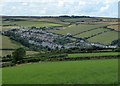
Millbrook from Maker
Looking down on the village of Millbrook from the junction of Image] and the B3247 near to Maker Heights.
Image: © Rob Farrow
Taken: 28 Jul 2019
0.08 miles
7
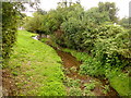
The Mill Brook, Millbrook
One of the small streams on the Rame peninsula.
Image: © Jonathan Billinger
Taken: 14 Aug 2018
0.10 miles
8
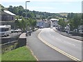
Millbrook
From Greenland, across the junction with The Parade. Prominently rising above houses in the centre is the Methodist Church, 1873, listed and described at https://historicengland.org.uk/listing/the-list/list-entry/1309932 .
Image: © Derek Harper
Taken: 11 May 2019
0.11 miles
9
Entry to Millbrook car park
The village's car park is to the left out of shot, the Mill Brook to the right.
Image: © Jonathan Billinger
Taken: 14 Aug 2018
0.11 miles
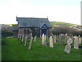
10
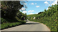
B3247 approaching Millbrook
Seen from beside the cemetery. The first building on the right is the burial ground's mortuary chapel, built in 1904; see https://millbrookheritage.com/history .
Image: © Derek Harper
Taken: 11 May 2019
0.12 miles