IMAGES TAKEN NEAR TO
Grandtully, PITLOCHRY, PH9 0PX
Introduction
This page details the photographs taken nearby to PH9 0PX by members of the Geograph project.
The Geograph project started in 2005 with the aim of publishing, organising and preserving representative images for every square kilometre of Great Britain, Ireland and the Isle of Man.

There are currently over 7.5m images from over14,400 individuals and you can help contribute to the project by visiting https://www.geograph.org.uk
Image Map
Images are licensed for reuse under creativecommons.org/licenses/by-sa/2.0
Notes
- Clicking on the map will re-center to the selected point.
- The higher the marker number, the further away the image location is from the centre of the postcode.
Image Listing (5 Images Found)
Images are licensed for reuse under creativecommons.org/licenses/by-sa/2.0
Image
Details
Distance
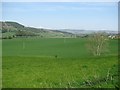
2
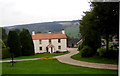
Sketewan farm
On the south bank of the River Tay.
Image: © Russel Wills
Taken: 20 Oct 2009
0.01 miles
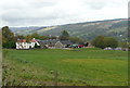
3
Sketewan Farm
Viewed from the Dalguise to Grandtully road. Self catering apartments are available at the farm.
Image: © Dave Fergusson
Taken: 28 Sep 2010
0.01 miles
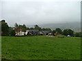
5
Haugh, Ballintaggart
Arable land on the flood plain of the River Tay. The Aberfeldy Branch of the Highland Railway crossed the haugh here, but there is no trace left at this point.
Image: © Richard Webb
Taken: 23 May 2012
0.24 miles