IMAGES TAKEN NEAR TO
Ardgour, FORT WILLIAM, PH33 7AH
Introduction
This page details the photographs taken nearby to PH33 7AH by members of the Geograph project.
The Geograph project started in 2005 with the aim of publishing, organising and preserving representative images for every square kilometre of Great Britain, Ireland and the Isle of Man.

There are currently over 7.5m images from over14,400 individuals and you can help contribute to the project by visiting https://www.geograph.org.uk
Image Map
Images are licensed for reuse under creativecommons.org/licenses/by-sa/2.0
Notes
- Clicking on the map will re-center to the selected point.
- The higher the marker number, the further away the image location is from the centre of the postcode.
Image Listing (23 Images Found)
Images are licensed for reuse under creativecommons.org/licenses/by-sa/2.0
Image
Details
Distance
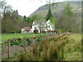
1
Sheep feeding station
Among the trees near Keil House.
Image: © Dave Fergusson
Taken: 7 Feb 2010
0.03 miles
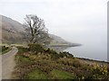
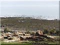
2
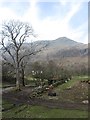
Beinn na Cille seen from Keil
A big steep hill seen from sea level.
Image: © Richard Webb
Taken: 24 Mar 2012
0.04 miles
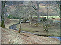
3
Allt Tairbh
A burn falling off Beinn na Cille reaches flat ground on the side of Loch Linnhe.
Image: © Richard Webb
Taken: 24 Mar 2012
0.06 miles
6
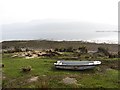
A boat beside Loch Linnhe
There is a fish farm in the background.
Image: © Richard Webb
Taken: 24 Mar 2012
0.10 miles
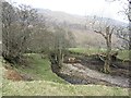
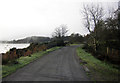
7
Shores of Loch Linnhe
The long way round road to Kinlocheil passes Camas na Cille.
Image: © Richard Webb
Taken: 24 Mar 2012
0.12 miles
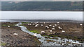
8
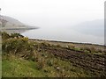
Camas na Cille
A dead calm Loch Linnhe at Camas na Cille.
Image: © Richard Webb
Taken: 24 Mar 2012
0.12 miles
9
An Camas Aiseig
Beach on the Ardgour side of Loch Linnhe.
Image: © Richard Webb
Taken: 24 Mar 2012
0.12 miles
10
Minor stream entering Camas na Cille of Loch Linnhe
Camas na Cille is a minor bay of the west side of Loch Linnhe. The stream entering the bay here is unnamed on OS maps at the 1:25 000 and 1:50 000 scales; it's the product of several more minor streams arising on the slopes of Sgurr na h-Eanchainne.
Image: © Trevor Littlewood
Taken: 16 Apr 2011
0.12 miles