IMAGES TAKEN NEAR TO
Cromarty Crescent, FORT WILLIAM, PH33 6LN
Introduction
This page details the photographs taken nearby to Cromarty Crescent, PH33 6LN by members of the Geograph project.
The Geograph project started in 2005 with the aim of publishing, organising and preserving representative images for every square kilometre of Great Britain, Ireland and the Isle of Man.

There are currently over 7.5m images from over14,400 individuals and you can help contribute to the project by visiting https://www.geograph.org.uk
Image Map
Images are licensed for reuse under creativecommons.org/licenses/by-sa/2.0
Notes
- Clicking on the map will re-center to the selected point.
- The higher the marker number, the further away the image location is from the centre of the postcode.
Image Listing (16 Images Found)
Images are licensed for reuse under creativecommons.org/licenses/by-sa/2.0
Image
Details
Distance
1
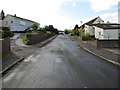
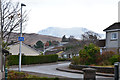
Cromarty Crescent in Fort William
Looking south-westward.
Image: © Peter Wood
Taken: 24 Sep 2019
0.01 miles
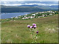
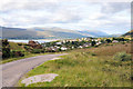
2
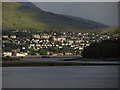
Fort William as seen from the shore at Corpach
Image: © Colin Park
Taken: 12 Jun 2012
0.06 miles
3
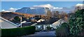
View of Ben Nevis from Old Military Road
View from the road with housing estate in front
Image: © Bartolo Creations
Taken: 25 Dec 2021
0.07 miles
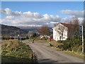
4
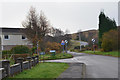
Last houses above Fort William
Loch View Crescent in Upper Auchintore beyond which the road continues as a single-track to Lundavra.
Image: © Jim Barton
Taken: 16 Nov 2019
0.09 miles
5
Ben Nevis in the back garden
Perhaps a slight exaggeration, but the snow-covered Carn Dearg makes a bold skyline for the houses in Upper Auchintore seen from Lundavra Road.
Image: © Jim Barton
Taken: 16 Nov 2019
0.09 miles
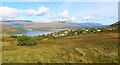
6
Fort William: view over the town from Blarmachfoldach
Looking north from Image across the town and Loch Linnhe.
Image: © Chris Downer
Taken: 7 Aug 2012
0.09 miles
7
Fort William and Loch Linnhe
Seen from Blarmachfoldach viewpoint on Lundavra Road.
Image: © Bill Kasman
Taken: 23 Sep 2020
0.09 miles
8
Achadh an Todhair - Upper Auchintore
The edge of Fort William on the Lundavra Road.
Image: © Richard Webb
Taken: 16 Mar 2008
0.09 miles
9
View over Upper Achintore, Fort William
Image: © Steven Brown
Taken: 24 Aug 2010
0.10 miles
10
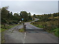
Lundavra Road
Lundavra Road heading over the cattle grid up to Blarmachfoldach
Image: © Shaun Ferguson
Taken: 25 Sep 2014
0.12 miles