IMAGES TAKEN NEAR TO
Bruces Buildings, FORT AUGUSTUS, PH32 4BB
Introduction
This page details the photographs taken nearby to Bruces Buildings, PH32 4BB by members of the Geograph project.
The Geograph project started in 2005 with the aim of publishing, organising and preserving representative images for every square kilometre of Great Britain, Ireland and the Isle of Man.

There are currently over 7.5m images from over14,400 individuals and you can help contribute to the project by visiting https://www.geograph.org.uk
Image Map
Images are licensed for reuse under creativecommons.org/licenses/by-sa/2.0
Notes
- Clicking on the map will re-center to the selected point.
- The higher the marker number, the further away the image location is from the centre of the postcode.
Image Listing (277 Images Found)
Images are licensed for reuse under creativecommons.org/licenses/by-sa/2.0
Image
Details
Distance
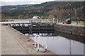
1
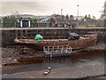
Caledonian Canal Fort Augustus Basin
A rusty steel hulled hulk sits on the bottom while the canal is dewatered to renew the lock gates at Fort Augustus and Kyltra
Image: © valenta
Taken: 15 Feb 2019
0.03 miles
2
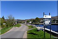
The Great Glen Way entering Fort Augustus
One of the few larger settlements on the Way between Fort William and Inverness
Image: © Tim Heaton
Taken: 5 May 2017
0.04 miles
3
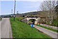
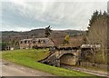
Old Railway Bridge
The Invergarry and Fort Augustus Railway used to run over this bridge; the line was closed in 1946. A swing bridge carried the line over the canal.
Image: © Robert Struthers
Taken: 9 Apr 2019
0.04 miles
4
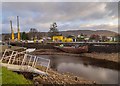
Dewatered Caledonian Canal Basin
Ongoing winter works where the canal lock gates are being renewed
Image: © valenta
Taken: 28 Nov 2019
0.04 miles
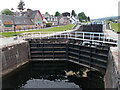
5
Caledonian Canal, Fort Augustus
This is the top lock of the flight of five that takes the Caledonian Canal down to Loch Ness. Although there is little evidence in this view, the canal was once crossed here by a railway - an extension to the Fort Augustus branch line to Fort Augustus Pier on the loch. The branch itself was closed to passengers in 1933, and completely in 1946, but this stretch had gone by 1924.
Image: © Stephen McKay
Taken: 2 Mar 2013
0.04 miles
6
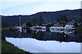
At berth at nightfall above the locks at Fort Augustus
Image: © Des Colhoun
Taken: 9 Apr 2008
0.04 miles
7
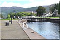
The upper lock, Fort Augustus
The top of the flight of five locks taking the Caledonian Canal down to Loch Ness.
Image: © Jim Barton
Taken: 3 Sep 2016
0.04 miles
8
Upstream on the Caledonian Canal
A series of canal locks at Fort Augustus.
Image: © Peter S
Taken: 31 May 2023
0.04 miles
9
Former Railway Bridge over Canal Side Road
Dating from around 1900 and category C listed, the bridge was built as an extension of the line from Fort Augustus to Inverness. It was only in use for three years, as the extension of the line to Inverness was abandoned.
https://britishlistedbuildings.co.uk/200391219-fort-augustus-former-railway-bridge-over-canal-side-road-aird-and-loch-ness-ward#.XGxXaqDgpaQ
Image: © valenta
Taken: 15 Feb 2019
0.04 miles
10
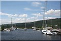
Caledonian Canal
This is the section of the canal from the top of the flight of locks at Fort Augustus, looking towards Loch Oich. The large yacht on the right is Second Wind, from Fort Lauderdale in Florida, USA. The one in mid-channel is also from Fort Lauderdale, but I could not quite read her name.
Image: © Anne Burgess
Taken: 22 Jun 2010
0.05 miles