IMAGES TAKEN NEAR TO
Eagle Avenue, AUCHTERARDER, PH3 1GD
Introduction
This page details the photographs taken nearby to Eagle Avenue, PH3 1GD by members of the Geograph project.
The Geograph project started in 2005 with the aim of publishing, organising and preserving representative images for every square kilometre of Great Britain, Ireland and the Isle of Man.

There are currently over 7.5m images from over14,400 individuals and you can help contribute to the project by visiting https://www.geograph.org.uk
Image Map
Images are licensed for reuse under creativecommons.org/licenses/by-sa/2.0
Notes
- Clicking on the map will re-center to the selected point.
- The higher the marker number, the further away the image location is from the centre of the postcode.
Image Listing (18 Images Found)
Images are licensed for reuse under creativecommons.org/licenses/by-sa/2.0
Image
Details
Distance
1
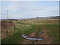
On the edge of Auchterarder
Farmland not being used at the time, probably due for housing development.
Image: © Richard Webb
Taken: 24 Apr 2013
0.07 miles
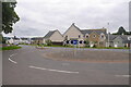
2
Benton Road / Hunter Street junction after house building
Image: © Richard Webb
Taken: 31 Aug 2020
0.08 miles
4
Edge of Auchterarder
The ground here is advertised locally as "The Castleton", a forthcoming housing development.
Image: © Richard Webb
Taken: 24 Apr 2013
0.14 miles
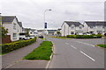
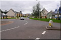
5
Roundabout and Castle Drive, Auchterarder
Image: © Richard Webb
Taken: 31 Aug 2020
0.14 miles
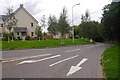
6
Castle Drive and new houses, Auchterarder
Image: © Richard Webb
Taken: 31 Aug 2020
0.14 miles
7
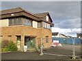
Stuart Milne, former office in Auchterarder
Image: © Richard Webb
Taken: 21 Feb 2022
0.14 miles
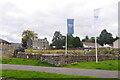
9
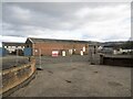
Auto & Plant, Auchterarder
Closed and fenced off along with an office of Stuart Milne on the site. More houses coming?
Image: © Richard Webb
Taken: 21 Feb 2022
0.16 miles
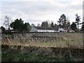
10
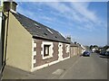
Feus, Auchterarder
Eastern end of Auchterarder's long street (former A9).
Image: © Richard Webb
Taken: 28 Mar 2022
0.18 miles