IMAGES TAKEN NEAR TO
Glenfarg, PERTH, PH2 9QJ
Introduction
This page details the photographs taken nearby to PH2 9QJ by members of the Geograph project.
The Geograph project started in 2005 with the aim of publishing, organising and preserving representative images for every square kilometre of Great Britain, Ireland and the Isle of Man.

There are currently over 7.5m images from over14,400 individuals and you can help contribute to the project by visiting https://www.geograph.org.uk
Image Map
Images are licensed for reuse under creativecommons.org/licenses/by-sa/2.0
Notes
- Clicking on the map will re-center to the selected point.
- The higher the marker number, the further away the image location is from the centre of the postcode.
Image Listing (7 Images Found)
Images are licensed for reuse under creativecommons.org/licenses/by-sa/2.0
Image
Details
Distance
2
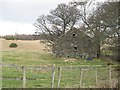
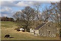
Stone byre, Abbots Deuglie
Substantial ruin.
Image: © Richard Webb
Taken: 9 Feb 2008
0.10 miles
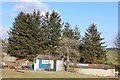
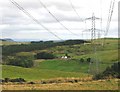
5
Power line, Glenfarg
Image: © Richard Webb
Taken: 30 Jul 2012
0.14 miles
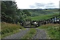
6
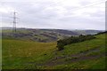
Power line, Glen Farg
The reservoir is hidden in the deep glen.
Image: © Richard Webb
Taken: 11 Nov 2018
0.19 miles
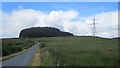
7
Ochil Pylons
Following the pylons South at the Eastern edge of the Ochil Hills, above Glenfarg Reservoir
Image: © Keith Proven
Taken: 14 Sep 2005
0.25 miles