IMAGES TAKEN NEAR TO
Bridge Of Earn, PERTH, PH2 9HD
Introduction
This page details the photographs taken nearby to PH2 9HD by members of the Geograph project.
The Geograph project started in 2005 with the aim of publishing, organising and preserving representative images for every square kilometre of Great Britain, Ireland and the Isle of Man.

There are currently over 7.5m images from over14,400 individuals and you can help contribute to the project by visiting https://www.geograph.org.uk
Image Map
Images are licensed for reuse under creativecommons.org/licenses/by-sa/2.0
Notes
- Clicking on the map will re-center to the selected point.
- The higher the marker number, the further away the image location is from the centre of the postcode.
Image Listing (6 Images Found)
Images are licensed for reuse under creativecommons.org/licenses/by-sa/2.0
Image
Details
Distance
2
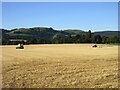
Harvested field of wheat near Kilgraston
Equipment left in a harvested wheat field near Kilgraston.
Image: © Scott Cormie
Taken: 30 Aug 2023
0.17 miles
3
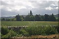
Across the fields
Looking towards Ballendrick House
Image: © Graeme Smith
Taken: 26 Jun 2008
0.19 miles
5
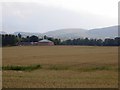
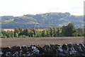
Stubble, Kilgraston
Looking towards Kilgraston School and the Ochil Hills.
Image: © Richard Webb
Taken: 1 Oct 2013
0.22 miles
6
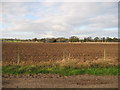
Ploughed field
Looking across farmland from track leading to Kilgraston School towards Ballendrick House. Stone wall following the line of the B935 marks the north edge of this square.
Image: © Jackie Proven
Taken: 15 Nov 2005
0.23 miles