IMAGES TAKEN NEAR TO
Clachan View, PERTH, PH2 9FF
Introduction
This page details the photographs taken nearby to Clachan View, PH2 9FF by members of the Geograph project.
The Geograph project started in 2005 with the aim of publishing, organising and preserving representative images for every square kilometre of Great Britain, Ireland and the Isle of Man.

There are currently over 7.5m images from over14,400 individuals and you can help contribute to the project by visiting https://www.geograph.org.uk
Image Map (Loading...)


Getting Data...Please wait
Leaflet Map data © OpenStreetMap
Images are licensed for reuse under creativecommons.org/licenses/by-sa/2.0
Notes
- Clicking on the map will re-center to the selected point.
- The higher the marker number, the further away the image location is from the centre of the postcode.
Image Listing (6 Images Found)
Images are licensed for reuse under creativecommons.org/licenses/by-sa/2.0
Image
Details
Distance
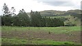
1
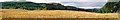
Gowk's Den panorama
Looking West from the road below West Dron. The wooded slopes (left and centre) form West Dron Hill, with Culteuchar Hill beyond.
Image: © Keith Proven
Taken: 18 Sep 2005
0.12 miles
2
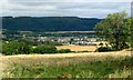
Bridge of Earn
From West Dron looking north
Image: © Keith Proven
Taken: 18 Sep 2005
0.13 miles
5
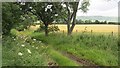
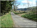
Green lane
An enclosed road, unsealed, crosses farmland.
Image: © Richard Webb
Taken: 30 Jul 2012
0.19 miles