IMAGES TAKEN NEAR TO
Forgandenny, PERTH, PH2 9DP
Introduction
This page details the photographs taken nearby to PH2 9DP by members of the Geograph project.
The Geograph project started in 2005 with the aim of publishing, organising and preserving representative images for every square kilometre of Great Britain, Ireland and the Isle of Man.

There are currently over 7.5m images from over14,400 individuals and you can help contribute to the project by visiting https://www.geograph.org.uk
Image Map
Images are licensed for reuse under creativecommons.org/licenses/by-sa/2.0
Notes
- Clicking on the map will re-center to the selected point.
- The higher the marker number, the further away the image location is from the centre of the postcode.
Image Listing (5 Images Found)
Images are licensed for reuse under creativecommons.org/licenses/by-sa/2.0
Image
Details
Distance
1
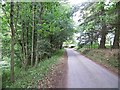
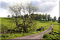
Road beside the Slateford Burn
Water is taken from the Slateford Burn for public water supply near here.
Image: © Richard Webb
Taken: 1 Oct 2013
0.12 miles
2
Slateford Burn
Beneath the Milnathort to Path of Condie road.
Image: © Richard Webb
Taken: 1 Oct 2013
0.13 miles
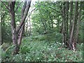
3
Fence by the roadside
Possibly a Water Board fence as there appears to be water treatment plant by the Slateford Burn beyond the trees.
Image: © Dave Fergusson
Taken: 1 Sep 2010
0.18 miles
4
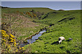
Slateford burn at the Whitehill farm roadend
The Slateford burn is a tributary of the Water of May.
Image: © Iain A Robertson
Taken: 28 Apr 2011
0.21 miles
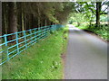
5
Entrance Driveway
The driveway which leads to the farm of Whitehill.
Image: © Glen Breaden
Taken: 31 May 2011
0.23 miles