IMAGES TAKEN NEAR TO
Rhynd, PERTH, PH2 8QE
Introduction
This page details the photographs taken nearby to PH2 8QE by members of the Geograph project.
The Geograph project started in 2005 with the aim of publishing, organising and preserving representative images for every square kilometre of Great Britain, Ireland and the Isle of Man.

There are currently over 7.5m images from over14,400 individuals and you can help contribute to the project by visiting https://www.geograph.org.uk
Image Map
Images are licensed for reuse under creativecommons.org/licenses/by-sa/2.0
Notes
- Clicking on the map will re-center to the selected point.
- The higher the marker number, the further away the image location is from the centre of the postcode.
Image Listing (7 Images Found)
Images are licensed for reuse under creativecommons.org/licenses/by-sa/2.0
Image
Details
Distance
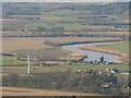
2
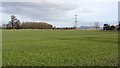
Flood plain, Easter Rhynd
Arable land where the Earn and Tay meet.
Image: © Richard Webb
Taken: 13 Feb 2012
0.07 miles
3
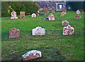
Churchyard at Easter Rhynd
The churchyard at Easter Rhynd is now disused, with the remains of the pre-1840 church overgrown with ivy. Many of the gravestones are collapsed and sunken into the ground. The church may originally have been established by benedictine monks in the 11th century.
Image: © William Starkey
Taken: 18 Jan 2011
0.10 miles
4
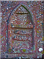
Detail of gravestone at Easter Rhynd
Many of the gravestones in Easter Rhynd churchyard are engraved with a "memento mori" which depicts the life of the deceased. This example is carved with two fish, possibly depicting the life of a fisherman. The nearby River Earn is famous for its salmon and sea trout.
Image: © William Starkey
Taken: 18 Jan 2011
0.10 miles

6
River Earn
The lower reaches of the Earn seen from Black Cairn Hill (I stood on the cairn to see over the whins)
Image: © Richard Webb
Taken: 30 Jan 2024
0.19 miles
7
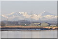
Easter Rhynd Farm from Newburgh
The snow covered mountains of Stuc a' Chroin and Ben Vorlich can be seen in the background, about 65km distant.
Image: © Iain A Robertson
Taken: 4 Dec 2009
0.21 miles