IMAGES TAKEN NEAR TO
Shore Road, PERTH, PH2 8BD
Introduction
This page details the photographs taken nearby to Shore Road, PH2 8BD by members of the Geograph project.
The Geograph project started in 2005 with the aim of publishing, organising and preserving representative images for every square kilometre of Great Britain, Ireland and the Isle of Man.

There are currently over 7.5m images from over14,400 individuals and you can help contribute to the project by visiting https://www.geograph.org.uk
Image Map
Images are licensed for reuse under creativecommons.org/licenses/by-sa/2.0
Notes
- Clicking on the map will re-center to the selected point.
- The higher the marker number, the further away the image location is from the centre of the postcode.
Image Listing (15 Images Found)
Images are licensed for reuse under creativecommons.org/licenses/by-sa/2.0
Image
Details
Distance
1
Quay at Perth
Perth was a major port in the middle ages, but it has just a small harbour these days.
Image: © Mike Pennington
Taken: 4 Aug 2011
0.04 miles
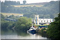
2
The Ingeborg Pilot at Perth Harbour
The cargo ship Ingeborg Pilot moored at Perth Harbour in June 2011, after a North Sea crossing from Thyboron in Denmark. The Ingeborg Pilot (built in 1981) is 63m x 11m, and has a deadweight of 1053 tonnes.
Image: © William Starkey
Taken: 5 Jun 2011
0.13 miles
3

River Tay by Moncrieffe Island
The overgrown western shore of Moncrieffe Island in the River Tay - it can be difficult accessing the water's edge here due to the undergrowth.
Image: © William Starkey
Taken: 16 Jun 2014
0.13 miles
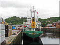
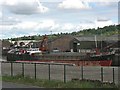
4
Perth Harbour
Perth Harbour is strategically located at the highest navigable point of the River Tay. In medieval times, cargoes were brought into the heart of the town, but nowadays the harbour is based at Frairton, about a mile downriver, in much deeper water.
Coastal and dry bulk ships up to 90 metres in length can be accepted into Perth Harbour, day or night, carrying up to 2500 tonnes. Vessels can be received on one high tide and depart on the next.
Cargoes range from traditional agricultural related cargoes such as animal feedstuffs and fertilisers to timber, chemicals and baryte ore.
Image: © Bob Jones
Taken: 12 May 2011
0.15 miles
5
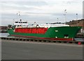
Perth harbour
The coaster ship Ida arriving at Perth with cargo of Swedish timber
Image: © DAVID MERSH
Taken: 24 Mar 2020
0.15 miles
6

Path by the River Tay
A faint and overgrown path on Moncrieffe Island alongside the River Tay.
Image: © William Starkey
Taken: 16 Jun 2014
0.17 miles
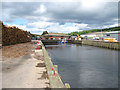
7
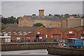
Perth Harbour
Perth Harbour is thirty miles from the sea so pilots are required to help navigate the more hazardous parts of the Tay. Cargoes which pass through Perth Harbour range from traditional agricultural related goods such as animal feedstuffs and fertilisers to timber, chemicals and baryte ore. The large building in the background is Perth Prison.
Image: © Paul McIlroy
Taken: 22 Sep 2007
0.18 miles
9

Boat moored in the River Tay
A boat moored in the River Tay viewed from Moncrieffe Island. This section of the river is tidal, and the rising tide is beginning to rotate the vessel on its mooring.
Image: © William Starkey
Taken: 16 Jun 2014
0.19 miles
10
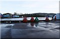
Full Up
Perth harbour almost spilling over. Taken approx 1 hour after high tide.
Image: © Karen Vernon
Taken: 16 Jan 2011
0.19 miles