IMAGES TAKEN NEAR TO
Manson Road, PERTH, PH2 8AQ
Introduction
This page details the photographs taken nearby to Manson Road, PH2 8AQ by members of the Geograph project.
The Geograph project started in 2005 with the aim of publishing, organising and preserving representative images for every square kilometre of Great Britain, Ireland and the Isle of Man.

There are currently over 7.5m images from over14,400 individuals and you can help contribute to the project by visiting https://www.geograph.org.uk
Image Map
Images are licensed for reuse under creativecommons.org/licenses/by-sa/2.0
Notes
- Clicking on the map will re-center to the selected point.
- The higher the marker number, the further away the image location is from the centre of the postcode.
Image Listing (9 Images Found)
Images are licensed for reuse under creativecommons.org/licenses/by-sa/2.0
Image
Details
Distance
1
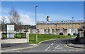
Entrance to HMP Perth
The entrance to HM Prison in Perth which is the oldest Scottish prison still (2022) in use. It dates from 1810 - 1812 when it was constructed to house French prisoners from the Napoleonic Wars.
Image: © Trevor Littlewood
Taken: 9 Apr 2022
0.07 miles

3

Recycling area
Recycling area in the corner of a supermarket car park. The Edinburgh Road railway bridge can just be seen between the trees to the left. Only paper and garden waste can be collected from the kerbside in Perth for recycling, so areas like this one meet a real need to recycle other materials.
Image: © Lis Burke
Taken: 26 Oct 2007
0.18 miles
4
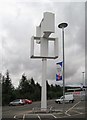
A wind turbine for your store
When I first saw this rotating structure I assumed it was intended to house some advertising or publicity. In fact it is a wind turbine designed to reduce the carbon footprint of the supermarket in whose car park it is located.
In connection with similar scheme at another store a company spokesman said, "We have been looking at a few sites across the UK as locations for these turbines ... ... ...it may only provide a small proportion of the total energy used in the supermarket, but this is part of a UK-wide initiative that we are committed to. We need to try to provide renewable energy at as many of our stores as possible."
http://www.energysavingtrust.org.uk/housingbuildings/funding/scottishbusiness/scottishnews/
The application for planning consent stated that the turbine would be capable of generating six kilowatts of electricity and have an estimated lifespan of 15 years.
Image: © Lis Burke
Taken: 5 Sep 2008
0.20 miles
5
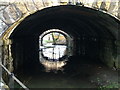
Craigie Burn
The Craigie Burn flowing under railway bridges near South Inch.
Image: © James Nicol
Taken: 2 Jan 2004
0.21 miles
6

Flooding recedes on the South Inch
Perth received 40mm of rainfall yesterday morning, causing flooding in many parts of the town centre. This area of the South Inch is designed to store water from the Craigie Burn Image Image when the river level is too high for it to flow out into the Tay. Now that the river level has dropped again the South Inch is starting to dry out.
Image: © Lis Burke
Taken: 22 Jul 2010
0.22 miles
7

Viaduct over the Craigie Burn
The path alongside the burn links the Craigie area of Perth with the park at South Inch
Image: © Alpin Stewart
Taken: 25 Feb 2014
0.23 miles
8

Benchmark, Craigie Railway Bridge, Perth
Ordnance Survey benchmark. For full description, see http://www.bench-marks.org.uk/bm65008.
Image: © Becky Williamson
Taken: 10 Mar 2015
0.23 miles
9

Judging at Perth Show
An impressive line-up in the judging ring, with the buildings of Perth prison behind.
Image: © Lis Burke
Taken: 7 Aug 2010
0.24 miles