IMAGES TAKEN NEAR TO
Glencarse, PERTH, PH2 7LT
Introduction
This page details the photographs taken nearby to PH2 7LT by members of the Geograph project.
The Geograph project started in 2005 with the aim of publishing, organising and preserving representative images for every square kilometre of Great Britain, Ireland and the Isle of Man.

There are currently over 7.5m images from over14,400 individuals and you can help contribute to the project by visiting https://www.geograph.org.uk
Image Map
Images are licensed for reuse under creativecommons.org/licenses/by-sa/2.0
Notes
- Clicking on the map will re-center to the selected point.
- The higher the marker number, the further away the image location is from the centre of the postcode.
Image Listing (8 Images Found)
Images are licensed for reuse under creativecommons.org/licenses/by-sa/2.0
Image
Details
Distance
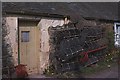
1

Inchyra
A row of traditional cottages makes up most of Inchyra.
Image: © Anne Burgess
Taken: 4 Jun 2008
0.04 miles
2
Creels
Creels stacked by a fishermen's bothy.
Image: © Anne Burgess
Taken: 14 May 1978
0.05 miles
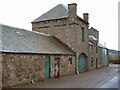
3
Inchyra
A house by the confluence of the Cairnie Pow with the Tay estuary, seen from the jetty. It wasn't always such a quiet place, because at one time there was a ferry across the Tay to Muirhead from here.
Image: © Anne Burgess
Taken: 31 May 1978
0.05 miles
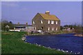
5
High Tide at Inchyra
Looking west from Inchyra on the River Tay. Kinfauns Castle on right and Elcho castle on left can be seen from here.
Image: © Alastair Muirhead
Taken: 4 May 2006
0.11 miles
6
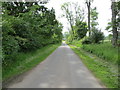
Tree-lined minor road to Inchyra
Looking southward.
Image: © Peter Wood
Taken: 22 Jun 2019
0.11 miles
7
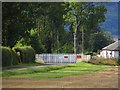
Closed level crossing
The road into Inchyra has been blocked by closing the level crossing. Another road to St Madoes is used instead.
Image: © Richard Webb
Taken: 30 Aug 2014
0.19 miles
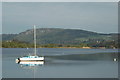
8
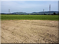
Farmland near Inchyra
Farmland at Inchyra adjacent to the River Tay. Pylons carrying the transmission grid over the Tay can be seen in the distance, together with hills in northern Fife.
Image: © William Starkey
Taken: 11 Jul 2013
0.22 miles